Subject: United States
Period: 1868 (circa)
Publication:
Color: Hand Color
Size:
26.3 x 18 inches
66.8 x 45.7 cm
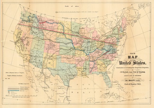
Handsome and well colored lithographic map drawn to show the planned transcontinental railroads. Color and line are used to delineate the various railroads including those Completed, Proposed, and Unfinished. Legend further locates gold, silver, quicksilver, and copper deposits through icons. The most interesting feature of the map is a blue line running along major rivers that connects the Atlantic and Gulf of Mexico with the Pacific Ocean. This line is labeled as the route to the Pacific Ocean as proposed in 1753 by Rev. James Maury. Given the limited of knowledge of the northwest, upper Missouri River and the Columbia River, one can only marvel at the route as depicted. Maury, along with Thomas Jefferson's father Peter, was one of the founding members of the Loyal Company that was created to petition for grants of land west of the Allegheny Mountains. Thomas Jefferson later attended Rev. Maury's school and no doubt was influenced by Maury in the idea of western exploration. Drawn by J.H. Waddell under the instructions of M.F. Maury, LLD, Prof. of Physics, Virginia Military Institute. A seldom seen and most desirable map.
References:
Condition: B
Issued folding, now pressed and backed with archival tissue. Nice original coloring and impression. Lightly toned along some folds in blank areas, else very good.