Subject: New York
Period: 1842 (dated)
Publication: Geology of New York
Color: Hand Color
Size:
50 x 22 inches
127 x 55.9 cm
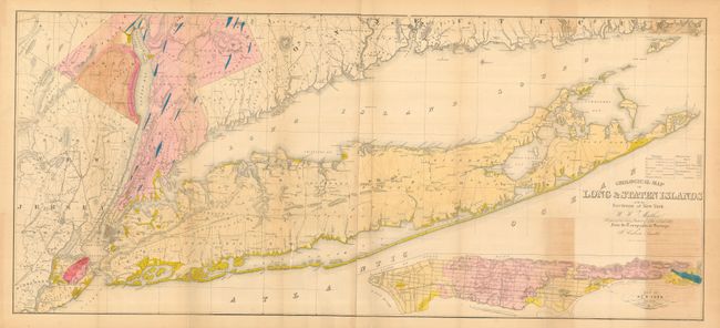
Undoubtedly one of the best, and most detailed, early maps of Long Island from the topographical surveys of Calvin Smith. Although labeled a geological map, its hand coloring, detailing of roads, villages, communities, and other political information make it a very desirable map. It covers Long Island and the rest of southern New York state, as well as Westchester and Rockland counties and northeastern New Jersey. At bottom right is a large inset of "New York Island" that features Manhattan and shows early roads in the upper reaches. A huge map on two sheets joined, as issued. The colorful sheet is further embellished with fancy lettering in the title.
References:
Condition: A
Lovely example with fine coloring and original margins. One small, light water stain or watercolor run in eastern Long Island, short repaired tear at binding trim that does not enter map. Also some light offsetting at lower right, still very good.