Subject: Nevada
Period: 1876 (published)
Publication: Geological and Topographical Atlas…Exploration of the Fortieth Parallel
Color: Printed Color
Size:
21 x 29 inches
53.3 x 73.7 cm
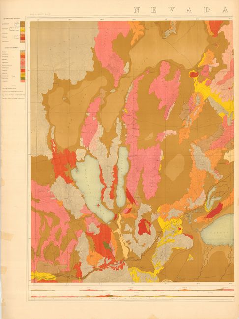
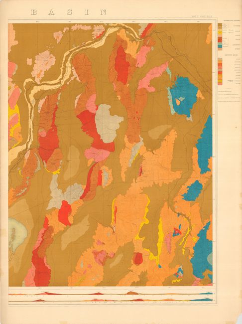
This large, colorful geological map is a product of Clarence King's monumental survey along the 40th Parallel. It is printed on two unjoined sheets, which if joined would measure approximately 42 x 29". Coloring and pattern are used to indicate twelve different eruptive rock types and ten sedimentary divisions. Elevation is shown via contour lines. Beneath each map is a detailed elevation plan and cross-section of the terrain that uses the same color and pattern to show geological structure. Together, the west and east sheets (Map V) cover the region between 120° and a little east of 117°, and from below 39° 30' North to above 41°, and locates Reno, Wadsworth, Mirage, White Plains, Granite Creek Station, Humboldt Lake, Carson Lake, Pyramid Lake, Rotten Egg Springs, Oreana, Winnemuca, Austin, Buffalo Spring, and much more. The location of all-important springs are shown throughout the region.
King was only 25 and a few years out of Yale when he was appointed Geologist in Charge of the Geological Exploration of the Fortieth Parallel. Earlier as a member of the Geological Survey of California he conceived the idea of a scientifically conducted geological survey along the route of the railroad then being built, which the War Department endorsed and funded. The survey party included two assistant geologists, three topographic aides, two collectors, a photographer, and other assistants. These two large maps represent a portion of their efforts.
References:
Condition: A
Printed on thick paper with a few marginal flaws, map is near fine.