Subject: World
Period: 1652-59 (circa)
Publication:
Color: Hand Color
This pair of double hemisphere world maps exemplify the more austere cartography of Nicolas Sanson, often referred to as the 'the father of French cartography.' Whereas the Dutch cartographers are known for their fabulous decorations and coloring, the French cartographers, led by Sanson, are known for pioneering the scientific method of cartography.
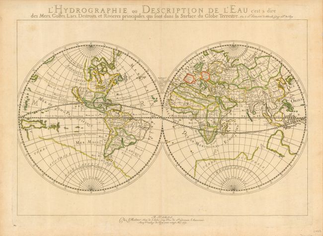
1) L'Hydrographie ou Description de l'Eau presents the world in eastern and western hemispheres. This map is similar to Sanson's 1651 edition (Shirley #390) but with more prominence given to marine and river features. California is shown as an island. But in this map Sanson has renamed Nouvelle Albion in the northwest part of North America as Terra de Iesso and the Detriot d'Anian has been moved to just north of California. This map is one of the first to distinguish the Great Lakes. Australia is only partially shown, still marked Beach, and there is a faint outline of the southern continent labeled Terre Australe Magellanique & Incogneue. (20.5 x 13.8")
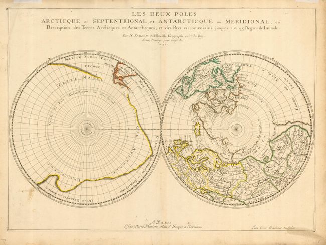
2) Les Deux Poles Arctique ou Septentrional, et Antarctique ou Meridional focuses on the north and south poles and illustrates the extent of exploration in the regions. In the Northern Hemisphere, Greenland is depicted attached to the American continent, and it is hinted that Terre de Yezo, ou Iesso takes up the entire region between Buttons Bay and East Asia. In the Southern Hemisphere, the tip of South America is shown with the Strait of Magellan and Le Maire Strait. The balance of the map is filled with a large landmass labeled Terre Magellanicque, Australe, et Incogneue. Engraved by Jean Somer Pruthenus and published by Pierre Mariette. (21 x 15.2")
References: 1) Shirley #394; 2) Shirley #408.
Condition: A
Good impressions with original outline color. Overall very good, second map with a bit of minor soil in map.