Subject: Eastern United States
Period: 1840 (dated)
Publication:
Color: Hand Color
Size:
9 x 7 inches
22.9 x 17.8 cm
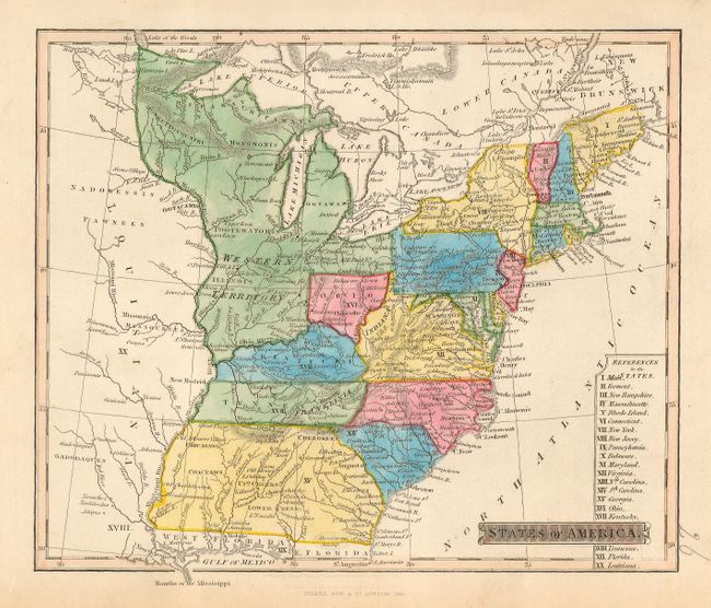
A colorful map that focuses on the eastern states up to the Mississippi River. This is a very late edition of this map that continues to show political boundaries from circa 1800. Most importantly, the map includes the short lived region of Franklinia in eastern Tennessee. Also shows a large Western Territory that covers today's Michigan and Wisconsin, and extends from Canada in the north, west to the Mississippi River, south to the Ohio River and all the way to Pennsylvania on its eastern boundary. Only the southern half of current day Ohio is labeled Ohio. The region of current day West Virginia is labeled Indiana without color distinction. Careful examination above the copyright notice shows in faint lettering "Nuttall, Fisher, & Dixon" but the date is not legible. Clearly the plate was re-engraved in this area for reissue by Fisher & Sons. Interestingly the earlier issue does not include Franklinia.
In 1785 settlers in present-day western North Carolina and eastern Tennessee organized a state government with the state to be named in honor of Benjamin Franklin. Congress turned down their appeal but the state maintained a legislature and governor until 1788. This ephemeral state appeared on a small number of maps into the early part of the 19th century. This map is apparently the latest published map to show the region.
References: Bayton-Williams, Map Collector Magaine p.72, #16.
Condition: A+
Clean and bright example with full margins. A little marginal toning or soiling in lower margins, still fine.