Subject: Colonial Midwest
Period: 1703 (published)
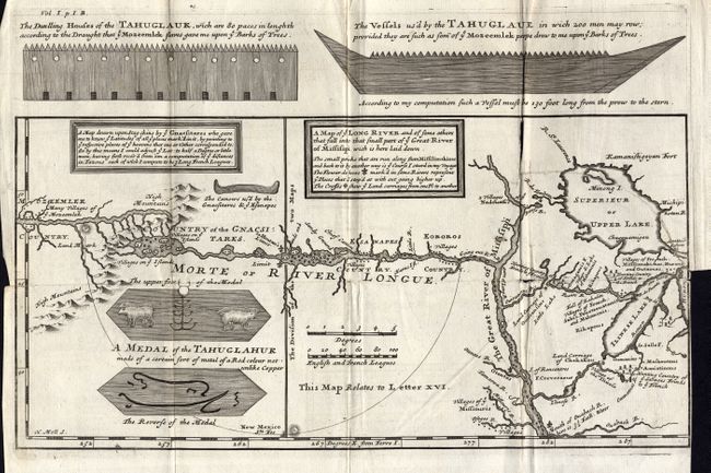
Publication: New Voyages to North America
Color: Black & White
Size:
13.3 x 6.6 inches
33.8 x 16.8 cm
One of the most influential, and fanciful, maps in American cartographic history. It purports to show the mythical River Longue flowing from the mountains in the west (Rocky Mts), home to the Gnacsitares Indians, and connecting to the Mississippi River. A number of relatively short portages across the High Mountains to what must be the River of the West are depicted. On the western side of the mountains is another river, presumably flowing into the Pacific. Lahontan's concept was copied by virtually all contemporary cartographers including Senex, Popple, and De l' Isle, thus perpetuating the myth through the 18th century. The map also includes balloon-shaped Lakes Superior and Michigan. This is the scarce first English edition, engraved by Herman Moll, with numerous interesting English text notations.
References: Schwartz & Ehrenberg #81, p. 142; Kershaw #306
Condition: B
Folding as issued. Fine impression on thick paper with large watermark. Binding side trim with 3" tear into map, closed on verso with archival tape. Short fold split with no loss.