Subject: Colonial New England
Period: 1774 (dated)
Publication:
Color: Hand Color
Size:
39 x 20.5 inches
99.1 x 52.1 cm
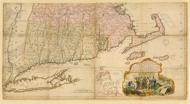
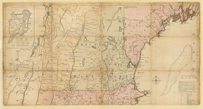
This is the third edition of Jefferys' celebrated large scale map of New England. This appears to be a separately issued example with segments that were likely issued in case map format and mounted on linen. Now backed with archival paper but all segments are evident. The map was first issued in 1755, at the beginning of the French and Indian War, and it became the most influential map of the region for the next several decades. The map was compiled by Bradock Mead (alias John Green) from influential contemporary sources, primarily Plan of the British Dominions of New England in North America (1753) by Dr. William Douglass. Credit is given to each of the surveys used in a table at right center, although Douglass' map is strangely omitted from the list. Jefferys' map represents the first widely disseminated, large format depiction of the region and is a significant improvement over the Douglass map, in part because of the additional territory covered and almost certainly the additional information which was likely available to Jefferys and Mead in the several years following the issue of the Douglass map. The map shows villages, towns, roads, counties, watershed, mountains and topography, and information along the coast, including islands and bays, and much more. There are two insets: "A Plan of Boston Harbor" and "A Plan of the Town of Boston." Maps from the American Atlas are certainly uncommon, but separately issued examples are particularly scarce. Originally folded, overall dimensions if joined, 39 x 41". Issued on four sheets, two joined horizontally. Both halves have been professionally encapsulated in archival Mylar.
References: Tooley (Amer) p.71; McCorkle 755.19; Pritchard & Taliaferro #35; Stevens & Tree #33(e).
Condition: B
Scattered toning or soiling and other small flaws. Lower margin trimmed to just above neatline. Slight loss at some segment intersections with a little manuscript to Rhode Island.