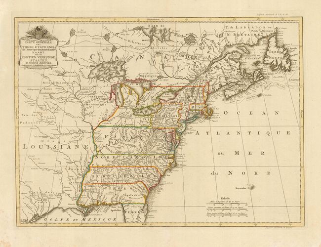
Subject: United States - Eastern
Period: 1785 (circa)
Publication: Nieuwe Atlas
Color: Hand Color
Size:
22.5 x 16.3 inches
57.2 x 41.4 cm
Uncommon map of the infant United States with the states extending to the Mississippi River and all land west of the Mississippi denoted as Louisiane. Pennsylvania is truncated with its western boundary partially formed by the Ohio River. Florida is confined to the peninsula leaving a large Georgia to incorporate all of present day western Florida, Alabama and Mississippi. It shows select towns and cities, forts, trails, and Indian tribal territory. There is a fascinating road running from Port Royal along the coast to Fort George, near Penobscot Bay. Roads are not generally shown on a map of this scale at this time, making that quite unusual. A shield above the title displays thirteen stars and stripes, an early acknowledgement of the newly independent nation and one of the earliest maps displaying the stars and stripes. It has been speculated that Reiner & Joshua Ottens originally made the plate for this map in 1755 under the title "Carte des possessions Angloises & Francoises du continent de l'Amerique Septentrionale". It was then acquired by Covens & Mortier and reworked to show the newly formed states and may have appeared as early as 1783.
References: McCorkle #785.3; Sellers and Van Ee #760.
Condition: A
Fine original outline color. Some foxing in wide margins, not affecting map.