Subject: Southwestern United States
Period: 1861 (circa)
Publication: Illustrated Family Atlas
Color: Hand Color
Size:
24.5 x 17 inches
62.2 x 43.2 cm
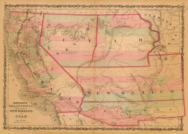
A very nice example of this early map from Johnson's Southwest series. The Confederate Territory of Arizona appears in the southern third of New Mexico Territory. Between August 1861 to July 1862, the Confederate General Baylor appointed himself the territorial governor and claimed all of New Mexico Territory south of the 34th Parallel for the Confederacy. The map names the Gadsden Ten Million Purchase of Mexico line between the U.S. and Mexico. Nevada Territory makes an early appearance with its boundary with Utah beginning near the Great Salt Lake but wandering south-southwest from Lake Sevier. Nevada was hastily added to this plate with 'Nevada' crudely fitted in an arc between the U and T of Utah. Filled with historical notes and notations including one note near Quartzite, Arizona referring to the area as being "fertile and abundantly timbered and well watered," which it most certainly is not. Details the Emigrant Road, the Hastings Road, and the routes of numerous explorers and military expeditions. The Gold Region of present-day Colorado's South Park is prominently shown in what was then Kansas. A great map of the Southwest.
References: Wheat [TMW] #1027.
Condition: B
Very nice impression and coloring and full, original margins. One spot in Southern California and a little light offsetting, short split along centerfold top and bottom (touching border at bottom), else very good.