Subject: Colonial New England
Period: 1768 (circa)
Publication:
Color: Hand Color
Size:
38.5 x 20.5 inches
97.8 x 52.1 cm
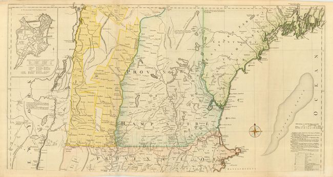
This is the top (2 of 4 sheets) section of one the most detailed 18th century maps of New England. This section covers the area from Penobscot Bay to just below Marblehead and inland to Lake Champlain and the Hudson River. Details include boundaries, towns, roads, trails, portages, forts, farms and topography. While the coastlines are not well represented, the map is remarkable for the early place names, landmarks and land grants in New Hampshire and Maine. A fine plan of Boston is inset at upper left. The map was originally published by Thomas Jefferys in 1755 and was the work of his assistant Braddock Mead, alias John Green. The map had a long publishing history and was updated with subsequent editions. This is at least the 4th state with the plan of Boston and the note above Saratogha Lake describing the border between New York and New Hampshire. Two sheets joined, as issued.
References: Cumming (COL) pp. 45-47; Pritchard & Taliaferro #35; McCorkle #755-19; Sellers & Van Ee #799.
Condition: A
Good impression and original color. Tissue repair of minor fold separation.