Subject: Michigan
Period: 1842 (dated)
Publication: Sen Doc 393, 27th Cong., 2nd Sess.
Color: Black & White
Size:
22.5 x 36.3 inches
57.2 x 92.2 cm
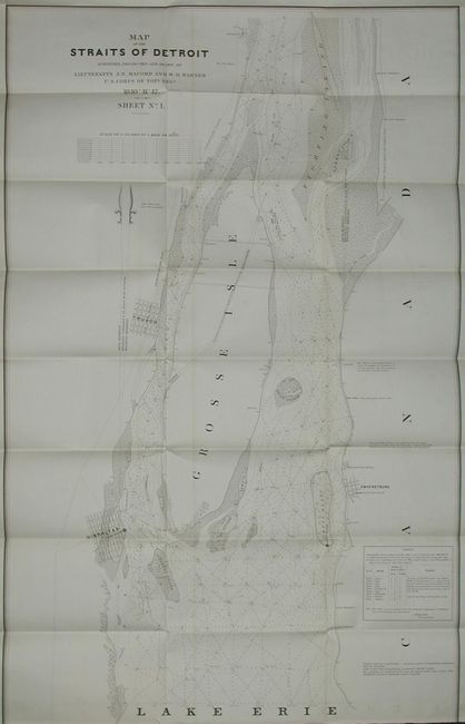
Large and finely drawn chart that covers the straits to include town plans of Gibraltar, Truaco and Amherstburg, Grosse Isle, Celeron Island, Bois Blanc, etc. Locates two old stone windmills, lime kiln, several roads including the Detroit and Ohio road, and several houses identified by owner including Maj. John Biddle and J. Dougall. Very detailed at a scale of 3 inches per mile. Table details historical high water flows beginning in 1830. A notation tells of a "very dangerous rock in front of J. Dougall's brick dwelling…" plus other interesting notations. Complete with the original 6 pp. report to Congress from the Secretary of War, J.C. Spenser, and written by Col. J.J. Abert and Captain W.G. Williams.
References: Claussen & Friis #418.
Condition: A
Fine impression on thick paper with no flaws. Binding trim at bottom into neatline, as issued, trace of offsetting in a couple places, else fine. The report itself has even overall toning.