Subject: United States - Southwestern
Period: 1858 (dated)
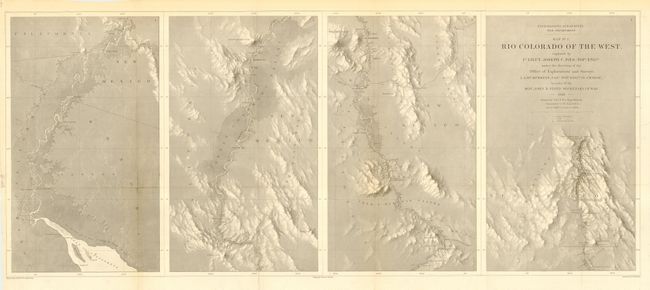
Publication: Report upon the Colorado River of the West
Color: Black & White
Size:
34.7 x 14.5 inches
88.1 x 36.8 cm
This map is the first in a series of four that represents one of the most important exploring efforts of the American Southwest. It shows the topography and geology of the lower Colorado River in four panels (each about 8.5" x 14"), beginning at the Gulf and ending in Black Canon at Fortification Rock. Fully and finely engraved with much detail. Wheat says this is one of the best maps by the remarkable F.W. von Egloffstein. It is engraved using his system that imparts the appearance of depth to the topography and nearly mimics a satellite image.
References: Wheat (TMW) #947.
Condition: A
Issued folding, now pressed and backed with archival tissue. Hint of toning along a fold, still very good.