Subject: United States - Northwestern
Period: 1827 (published)
Publication: Atlas Universel
Color: Hand Color
Size:
20.1 x 18.2 inches
51.1 x 46.2 cm
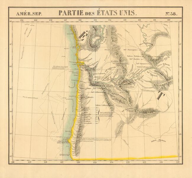
A most handsome sheet of the Northwest that includes parts of Washington and Oregon from 42 to 48 degrees latitude, and from 120 to 130 degrees longitude. A note mentions Lewis and Clark's arrival at the Pacific Ocean. The tracks of explorers ships are noted, including Cook, Vancouver and others. Extends to show much of Puget Sound, Mt Rainier, Mt. St. Helens, and Mt Jefferson. Locates Forts Astoria and Clatsop at the mouth of the Columbia River. A table gives the populations of 10 Indian tribes and numerous tribes are located throughout the map. The Atlas Universel was the first atlas to present all the maps on the same scale (1: 1,641,836), with each map covering an area of approximately 20 degrees longitude (from Paris) and 6 degrees of latitude. Also considered to be the first lithographic atlas ever published. Of these large-scale and highly detailed maps, Wheat said "No mapmaker had previously attempted to use such a large scale for any western American area." There was only one edition, published in 1825-27, and the subscription list shows that 810 copies were sold. A beautiful example of a remarkable and scarce map.
References:
Condition: A+
Lovely impression and original hand coloring on a full sheet with very wide margins. Map is encapsulated in Mylar.