Subject: Canada and New England
Period: 1840 (dated)
Publication:
Color: Hand Color
Size:
34 x 22.4 inches
86.4 x 56.9 cm
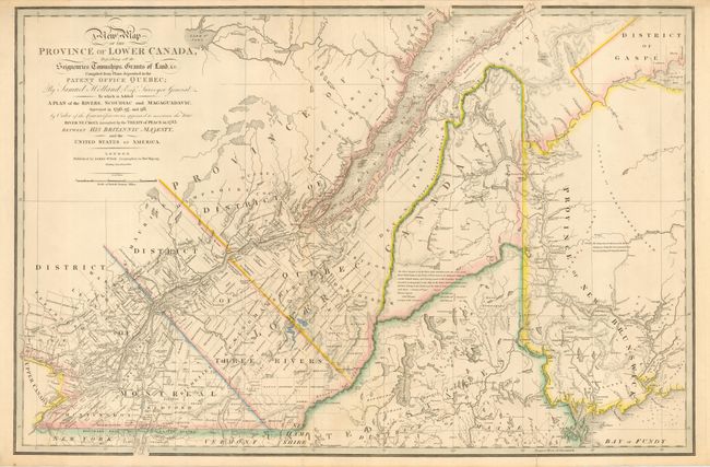
Title continues: "To which is Added A Plan of the Rivers Scouriac & Magaguadavic Surveyed in 1796, 97, and 98, by Order of the Commissioners, appointed to ascertain the true River St. Croix intended by the Treaty of Paris in 1783 Between His Britannic Majesty, and the United States of America." This boldly engraved map extends westward to include Lake St. Francis and the extreme tip of Upper Canada, eastward to part of New Brunswick showing the River St. John and beyond, and south to just below the Canadian border with New York and Vermont. It is filled with towns and settlements and individual named townships, roads and trails. It includes several interesting notations and delineates the "Boundary awarded to the King of Holland." Samuel Holland was originally a Dutch surveyor who fought on the side of the British during the French and Indian Wars and served as Surveyor General for the Province of Quebec and the Northern District of America. An infrequently seen issue.
References: Tooley (Amer) p.66 #28e
Condition: B
Fine impression with original coloring on thick paper. Folding, as issued. Two short splits just into map and a longer split well into map, else very good.