Subject: California
Period: 1849 (dated)
Publication: Ex. Senate doc. 47, 31st Cong., 1st Sess.
Color: Black & White
Size:
10.7 x 23.5 inches
27.2 x 59.7 cm
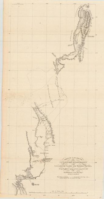
This map details the route of Warner's party from Benicia near San Francisco to Sacramento City, up the Sacramento River and into the High Sierras in the vicinity of Goose Lake. A note in the Sierra mountains states that there are "Mountains as far as the eye can see." Locates the Oregon Trail from the U.S. and the Oregon Trail from California. This nomenclature being very early references to the Oregon Trail that was normally called the Immigrant Route at this time. Provides a fascinating view of the trails, farms, mines etc. along the route. The map had great importance in providing the first information of the mountainous region northeast of the Central Valley, and as a source document on the Lassen Cutoff.
Capt. Warner was tasked with finding a suitable railroad route up the Sacramento Valley. Though he discovered a suitable pass, his party was ambushed by Indians and he was killed (the location of his death is marked on the map). His notes and a sketch map were rescued, and from these Lt. Williamson was able to produce this map and a report, which were the first published documents to show any detail of this country.
References: Wheat (TMW) #700; Wheat (Gold) #182.
Condition: A
Margin extended at bottom for framing. A couple of spots in map, still very good. Issued folding, now pressed and backed with archival tissue.