Subject: Colonial Mid Atlantic and Great Lakes
Period: 1758 (dated)
Publication:
Color: Hand Color
Size:
26.2 x 19 inches
66.5 x 48.3 cm
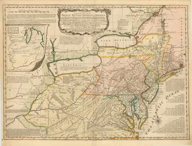
This is the first state of Thomas Jefferys' derivative of the seminal Lewis Evans map of the Middle British colonies, which was one of the landmarks of American cartography. It illustrates the region from Montreal and the lower end of Lake Huron to the North Carolina border, and from the Falls of the Ohio to Narragansett Bay, with an inset of the Illinois Country. Evans' map contributed enormously to the cartographic knowledge of the Ohio Valley, the region that was at the center of friction between England and France.
Jefferys' edition emphasized the enormous stakes involved in the French and Indian War. He also improved on Evans' map by depicting the British and French forts in the area of the Ohio River that had been recently built. It also contains several additional important notations including descriptions of the lands claimed by the different Indian tribes, especially the Confederate Nations. One of the most interesting of these notations reads, "Were there nothing at Stake between the Crown of Britain and France but the Lands of the Ohio, we may reckon it as great a Prize as has ever been contended for between two nations." Imprint at bottom right: Sold by T. Jefferys, Charing Cross 1758. Price 2s: 6d.
References: McCorkle 758.3; Steven & Tree #30-b.
Condition: A+
Fine impression and original color. Very faint toning along fold, still fine.