Subject: Mexico and United States
Period: 1847 (published)
Publication:
Color: Black & White
Four fine plans detail areas of operations in the Mexican & American War.
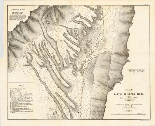
1) "Plan of the Battle of Buena-Vista Fought February 22nd and 23rd 1847 Surveyed by Cap. Linnard and Lieuts. Pope & Franklin, Corps. T. Engrs." Lithographic map drawn by Capt. Linnard and surveyed by Lieutenants Pope and Franklin. A very detailed battle plan showing a crucial battle in the Mexican-American War. Outnumbered nearly 5 to 1, General Taylor's forces held, and finally defeated the advancing Mexican forces under General Santa Ana. A legend notes troop locations during the battle. 20 x 16".
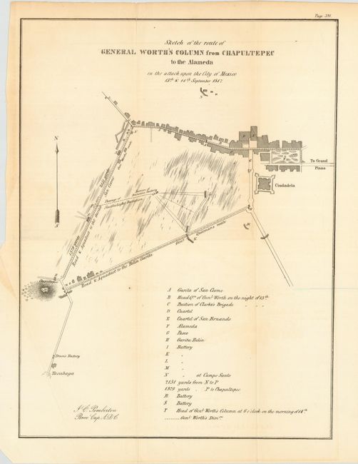
2) "Sketch of the route of General Worth's Column from Chapultepec to the Alameda in the attack upon the City of Mexico 13th & 14th September 1847" Detailed map depicting the positions of batteries, headquarters, troops, and buildings on the outskirts of Mexico City. Includes the roads and aqueducts to Garita San Cosme and Belin Garita. 10.5 x 14.2".
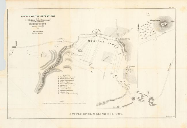
3) "Sketch of the Operations of the 1st Division United States Army under the command of General Worth on the 8th Sept. 1847 by Edmd. L.F. Hardcastle… Battle of El Molino del Rey." A temporary armistice between Mexican President Santa Anna and commanding General Scott that arranged for a treaty of surrender had broken down and Gen. Scott decided to make a final effort to capture Mexico City. This map shows details of the first operation against El Molino del Rey that began early on September 8th. The map and indexed legend locates the positions of 11 different groups during the battle. A simultaneous attack was made against Casa de Mata. The Mexicans were soundly defeated, but only after a hard fought action with severe casualties on both sides. According to General Winfield Scott's official report to William Marcy, Secretary of War, Molinos del Rey was a mill that contained a cannon foundry. It had a large deposit of powder nearby and many church bells had recently been delivered to be cast into guns, which hastened his resolve "to seize the powder, and to destroy the foundry." 19.4 x 12.7".
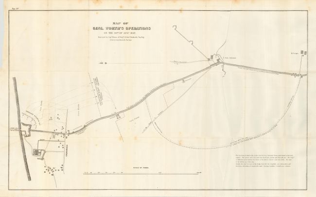
4) Map of Genl. Worth's Operations on the 20th of Augt. 1847. Surveyed by Capt. Mason of Engrs. & Lieut. Hardcastle,…" Scale in yards. San Antonio with high road to Churubusco including details of buildings and fortifications. 30.5 x 18".
References:
Condition: A
All in mostly good condition, occasional fold intersection splits. The second map is B condition with a little fold-line toning and short fold splits. The last map has a few faint spots.