Subject: Colonial Southeast
Period: 1634 (published)
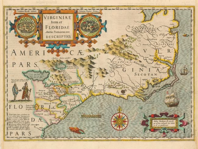
Publication: Gerardi Mercatoris Atlas sive Cosmographicae
Color: Hand Color
Size:
19 x 13.5 inches
48.3 x 34.3 cm
Superb map compiled from John White's Virginia and Jacques le Moyne's Florida as interpreted by Theodore de Bry. Largely due to the enormous success of this atlas, Le Moyne's erroneous depiction of a large inland lake from which the R. de May (St. John's River) flows in a southeasterly direction was popularized. Chesapeake Bay, here called Chesepioock Sinus, and the area south towards C.S. Romano Hispanis are shown in their White delineations. The Indian villages of Paquiwok, Croatoan, and Wococon are named in the Outer Banks and several others along the Albemarle and Pamlico Sounds. The map is extensively decorated with depictions of Indian villages incorporated in the title cartouche, a Floridian king and queen and Virginian natives in a canoe taken from De Bry, wildlife including a wild turkey, ships, sea monsters and a superb compass rose. Dutch text on verso.
References: Burden #151; Cumming #26; Williams & Johnson #3.
Condition: B
Strong impression and attractive color. Side margins trimmed but still adequate for framing. Light mat burn in blank margins. Small section of paper replaced in lower right corner with bit of expert facsimile to neatline.