Subject: North Atlantic
Period: 1657 (circa)
Publication: Atlas Novus, Sive Theatrum Orbis Terrarum….
Color: Hand Color
Size:
22.5 x 17.4 inches
57.2 x 44.2 cm
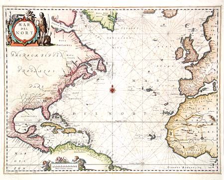
This map was originally published in Jansson's important sea atlas, Atlantis Majoris Quinta Pars, Orbem Maritimum, the first of its kind intended for the general market, and incorporated into his later publications. The chart covers the northern Atlantic Ocean with the eastern coast of North America, the West Indies, and the coasts of Europe and North Africa. Cartographically based on the previous maps produced by Hondius and Jansson, with a few notable improvements. A lake full of large islands and a complex system of waterways feeding the St. Lawrence River replaces the single Great Lake. There is a significant improvement in the delineation of the coastline between Chesapeake Bay and Long Island and in the north it shows Groenlandia separated by Meta Incognita. The handsome chart is arrayed with rhumb lines radiating from a central compass rose, and the title and distance scale cartouches features a Native American, several putti and a variety of indigenous animals.
References: Phillips (A) #5944 Vol. V #3; Burden #290.
Condition: C
Scattered foxing and a few marginal tears, closed. Three areas of cracking in map due to oxidized green, with no loss. Despite these flaws the map shows very well. Should be professionally conserved to arrest the oxidation.