Subject: Wyoming
Period: 1874 (dated)
Publication: Pub. HR ex doc 285 43rd Congress. 1st Sess.
Color: Printed Color
Size:
17.8 x 30.8 inches
45.2 x 78.2 cm
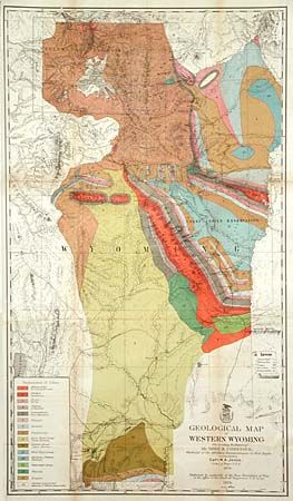
A handsome and colorful map that illustrated the report of T.B. Comstock, the geologist to the Military Reconnaissance of the region conducted by W.A. Jones. Shows fifteen classes of geology, the topography and trails of Northwestern Wyoming, including roads, stage stations, military posts and boundaries of the Snake Indian Reservation. Includes Jackson Hole, Big Horn and Teton Mountains, and extends south to Fort Bridger and Sweetwater Mountains. Terrific detail of the newly formed Yellowstone Park.
References:
Condition: B
Issued folding, now back with archival tissue. A small chip and crease on lower edge margin. A little toning along folds, else very good with fine coloring.