Subject: United States
Period: 1859 (dated)
Publication:
Color: Hand Color
Size:
26.2 x 15.6 inches
66.5 x 39.6 cm
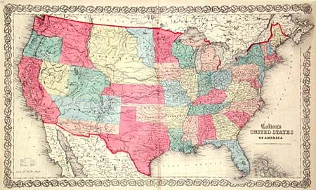
A very scarce map of the United States with superb provisional western territorial boundaries. Dakota Territory takes in the region between Minnesota and the Missouri River, with Nebraska taking in the rest of the region up to the Rocky Mountains. Kanzas Territory borders Utah and New Mexico in the west. The proposed Colona Territory (present-day Colorado) is shown by dotted line. Washington Territory wraps around Oregon taking in present-day Idaho. Most unusual is a proposed Nevada Territory with its eastern border along the 114th meridian down to Preuss L., then following the Virgin River to the New Mexican boundary. The proposed Arizona Territory is shown in the southern part of New Mexico. Several exploration routes are shown, including Fremont, Marcy, and Kearney. This is by far the best mid-nineteenth century map of the United States published in atlas format. Published by Johnson & Browning.
References:
Condition: B
Tear in bottom margin extending into decorative border and separations on top and bottom fold, all closed with archival tape. Otherwise a very clean map with bright color.