Subject: North Pole
Period: 1655 (circa)
Publication:
Color: Hand Color
Size:
20.8 x 16.1 inches
52.8 x 40.9 cm
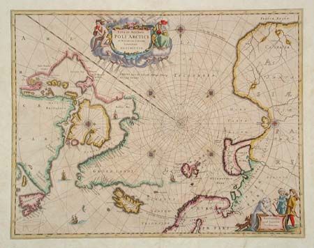
This beautiful map eventually replaced Hondius' map of the North Pole and became the prototype for many later maps including those of Blaeu. Rhumb lines radiate from the North Pole and several compass roses embellish the chart. A large title cartouche, with two figures and numerous wind heads, conveniently hide the northwest coast of America. The map is further decorated with ships and a cartouche, with Jansson’s imprint, which depicts men in parkas, a polar bear and foxes. This example is a state not noted by Burden; it would fall between state 3 and 4 with the land bridge between Nova Zemla and the mainland and Spitzbergen with a completed coastline, but lacking the IV in the top right corner. No text on verso.
References: Burden #250; Kershaw #110.
Condition: B
Fine original color with slightly uneven toning. Map has been trimmed to the neatline and mounted on hand laid paper for binding into a composite atlas; a common practice in the 18th century.