Subject: Asia
Period: 1544-72 (published)
Publication: Cosmographia Universalis
Color: Black & White
Size:
13.5 x 10 inches
34.3 x 25.4 cm
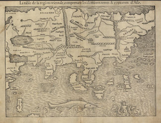
One of the earliest maps of the whole continent. Munster based the map on recent geographical discoveries by Portuguese navigators. The outline of the Asian mainland is relatively well established. India appears as a peninsula and Sri Lanka, called Zalon, is correctly located. Cambay, Goa and Cannonore are all shown, reflecting the Portuguese presence on India's west coast. Malacca is correctly located on the Malay Peninsula and the Indonesian island of Sumatra has inherited the name Taprobana from Sri Lanka, but also bears the name Sumatra. Java appears as two islands, Java Maior and Java Minor. The famed Spice Islands of Moluccas are located, but oddly shaped. The coastline of China is fairly accurate but Korea and Japan are absent. Northern Asia is named India Superior with the eastern most part left off the map. The Indian Ocean is filled with a huge sea monster and a fantastic two-tailed mermaid. French text on verso.
References: Ref: Yeo #2.
Condition: B
Strong impression, which is unusual for an early wood-block map. A marginal tear and split just entering map, both repaired with archival tissue on verso with small loss of paper in blank margin. A little toning, else very good.