Subject: Gulf of Mexico and Caribbean
Period: 1684 (circa)
Publication: Atlas Minor…
Color: Hand Color
Size:
22 x 18 inches
55.9 x 45.7 cm
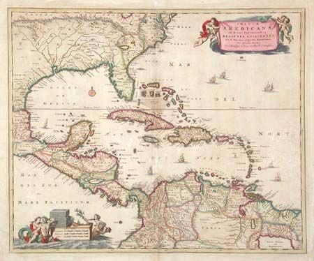
Decorative map of the Caribbean covering the region from the Chesapeake through the Gulf of Mexico, with Central America and the northern part of South America. Two lovely cartouches with cherubs and mermaids decorate opposite corners. Eight ships sail the seas and three native canoes are depicted off the coast of North America. A number of interesting cartographic myths appear on the map. These include two large nonexistent lakes in the region of western Georgia, a non-existent mountain range extending from the Piedmonts right across the continent, and the archetypal cartographic myth, Manoa o' El Dorado, located on Lacus Parime in Guyana.
References: Portinaro & Knirsch #82.
Condition: B
Attractive original color with slight oxidation. Minor scattered foxing and a couple of minor creases. Paper added in right blank margin.