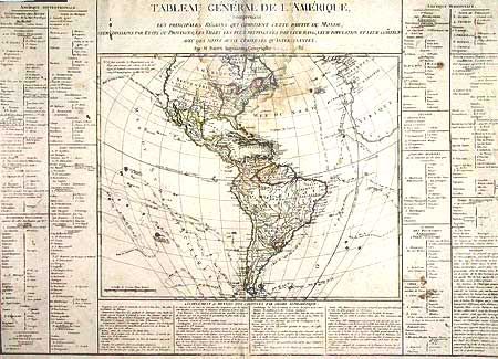
Subject: Western Hemisphere
Period: 1785 (dated)
Publication:
Color: Hand Color
Size:
17.4 x 14 inches
44.2 x 35.6 cm
This large map of the Americas provides a detailed view of the colonial possessions and the most recent explorations. The new United States is shown with its boundary on the Mississippi River. Both Florida and Louisiana are shown under Spanish control. The Northwest coast of North America is labeled Decouvertes des Russes and is largely blank in the interior. Numerous exploration routes are charted including those of Cook, Bougainville, Biron and the Spanish Manila to Acapulco route is shown. Map is surrounded on three sides with panels of French text on a sheet measuring 28.5 x 20.3". Sold with all faults, not subject to return.
References:
Condition: C
Trimmed to neatlines of text. Damp stain at center top and some scattered stains in text. Map has been laid down on modern paper to reinforce the weakened paper and repair some tears in the text. Some creasing throughout.