Subject: Atlases - Boston
Period: 1886 (dated)
Publication:
Color: Printed Color
Size:
13 x 15.6 inches
33 x 39.6 cm
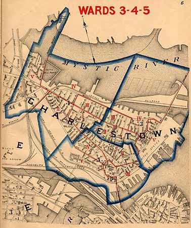
A great atlas with a fascinating bit of history. The maps were made by the City Surveyor to show the new voting precincts established by the City Council in 1885. While the maps were being printed, the Supreme Court of Massachusetts declared the laws providing for a decennial division of wards to be unconstitutional. A notice from the City Clerk, tipped in at title page, explains the problem and notes, "This volume is preserved merely as a convenient collection of street maps, all drawn on the same scale, and the only ones yet in print for Boston. It must be remembered that they do not give the present legal boundaries of the ward and precincts. Later on there will be an issue of maps showing the present wards and precincts." 15 maps (on 28 pages) on a scale of 800 feet to the inch. Small folio, original brown cloth boards with gilt title and seal of the city.
References:
Condition: B
Front cover and endpapers nearly detached. Pencil signature of Ronald Madden, 10/30/1886 on front endpaper. Minor offsetting to maps.