Catalog Archive
Auction 100, Lot 100

"Carte de M Danville du Nord de l'Amerique", Anon.

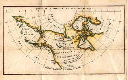
Subject: North America - Arctic

Period: 1789 (circa)

Publication:

Color: Hand Color

Size:
13.8 x 7.8 inches
35.1 x 19.8 cm
Download High Resolution Image
(or just click on image to launch the Zoom viewer)

An unusual small map of the Arctic regions of North America and the coast of Asia showing only coastal place names. Alaska is fairly well formed. A passage between Repulse Bay and the Arctic Ocean is noted as discovered by Cluny in 1768. There is also a notation spanning Canada concerning the long sought after Northwest Passage.

References:

Condition: B

Folding as issued with minor soil.

Estimate: $100 - $130

Sold for: $55

Closed on 9/12/2002

Archived