Showing Featured Lots(remove filter)
Filtered by Category:United States(Show All Categories)
Showing results for:Auction 174
Catalog Archive
12 lots
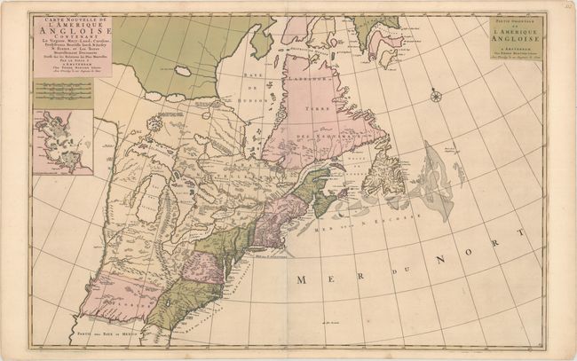
Auction 174, Lot 111
Subject: Colonial Eastern United States & Canada
Mortier, Pierre
Carte Nouvelle de l'Amerique Angloise Contenant la Virginie, Mary-Land, Caroline, Pensylvania Nouvelle Iorck. N: Iarsey N: France, et les Terres Nouvellement Decouerte..., 1700
Size: 35.9 x 23.5 inches (91.2 x 59.7 cm)
Estimate: $2,200 - $2,500
A Map Showing Fascinating Geographic Misconceptions in Colonial America
Sold for: $1,200
Closed on 9/11/2019
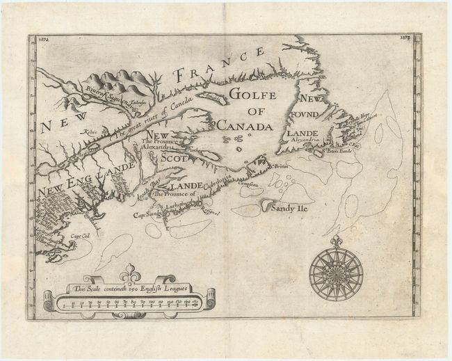
Auction 174, Lot 114
Subject: Colonial Northeastern United States & Canada
Alexander, William (Sir)
[Untitled - Northeastern United States & Canada], 1625
Size: 13.5 x 9.8 inches (34.3 x 24.9 cm)
Estimate: $5,500 - $7,000
The First Map to Name New Scotland
Sold for: $4,000
Closed on 9/11/2019
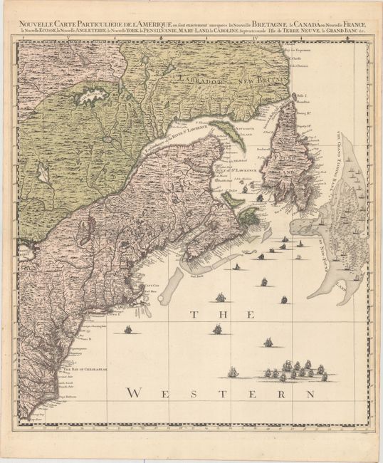
Auction 174, Lot 115
Subject: Colonial Northeastern United States & Canada
Popple/Covens & Mortier
Nouvelle Carte Particuliere de l'Amerique ou sont Exactement Marquees la Nouvelle Bretagne, le Canada ou Nouvelle France, la Nouvelle Ecosse, la Nouvelle Angleterre, la Nouvelle York, la Pensilvanie, Mary-Land, la Caroline Septentrionale..., 1741
Size: 20.7 x 22.5 inches (52.6 x 57.2 cm)
Estimate: $2,200 - $2,500
The Northeastern Sheet of the Reduced-Size Edition of Popple's Map
Sold for: $1,600
Closed on 9/11/2019
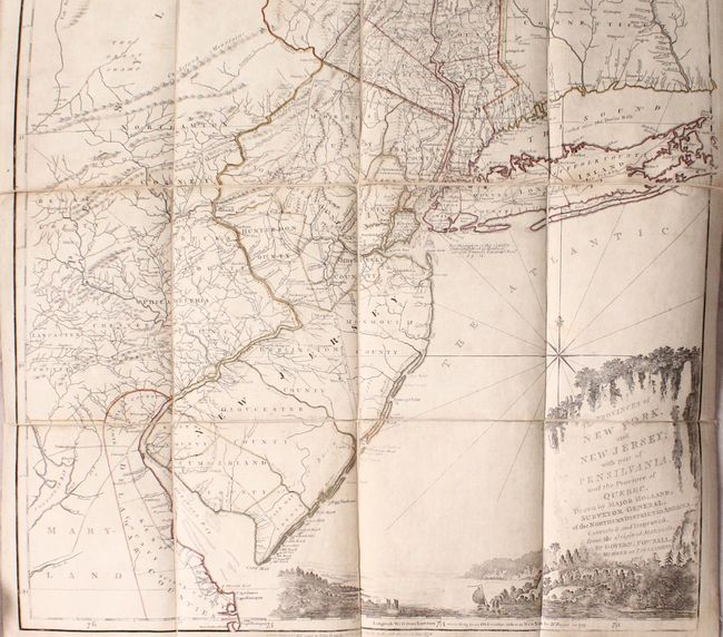
Auction 174, Lot 116
Subject: Colonial Northeastern United States & Quebec
Holland/Pownal
The Provinces of New York, and New Jersey; with Part of Pensilvania, and the Province of Quebec..., 1776
Size: 21.5 x 53.3 inches (54.6 x 135.4 cm)
Estimate: $4,000 - $4,750
Thomas Jefferys' Important Revolutionary War Period Map
Sold for: $2,500
Closed on 9/11/2019
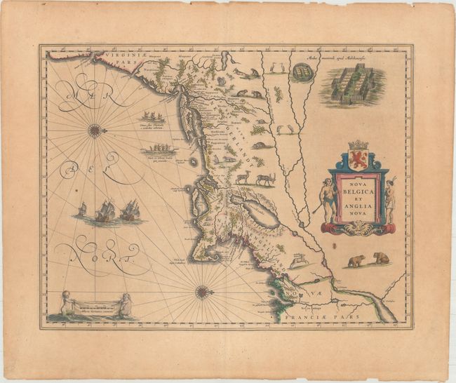
Auction 174, Lot 139
Subject: Colonial New England & Mid-Atlantic United States
Blaeu, Willem
Nova Belgica et Anglia Nova, 1643
Size: 19.8 x 15.1 inches (50.3 x 38.4 cm)
Estimate: $1,900 - $2,200
Important Map of Colonial New England and the Mid-Atlantic
Sold for: $1,150
Closed on 9/11/2019
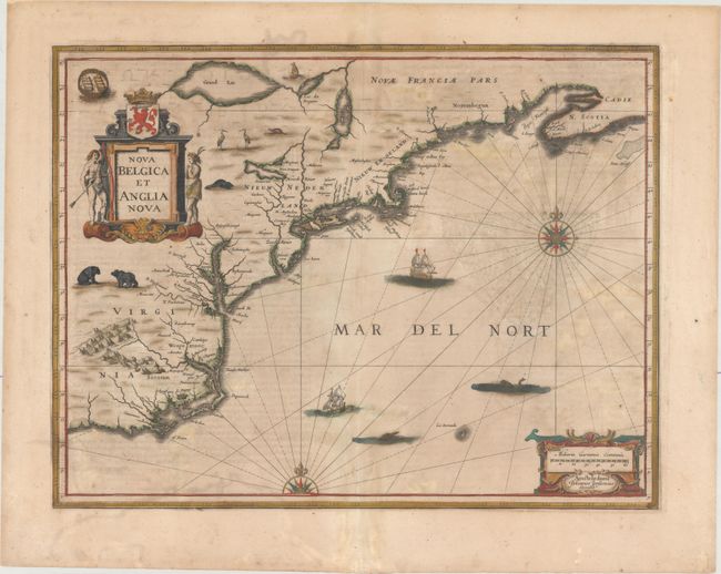
Auction 174, Lot 140
Subject: Colonial New England & Mid-Atlantic United States
Jansson, Jan
Nova Belgica et Anglia Nova, 1647
Size: 19.8 x 15.2 inches (50.3 x 38.6 cm)
Estimate: $1,500 - $1,800
Jansson's Influential Map of the East Coast
Sold for: $1,000
Closed on 9/11/2019
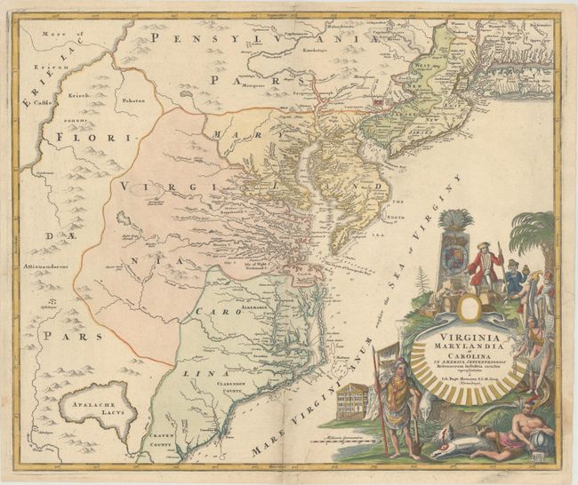
Auction 174, Lot 151
Subject: Colonial Mid-Atlantic United States
Homann, Johann Baptist
Virginia Marylandia et Carolina in America Septentrionali Britannorum Industria Excultae Repraesentatae, 1730
Size: 22.8 x 19.1 inches (57.9 x 48.5 cm)
Estimate: $1,600 - $2,000
Map Created to Promote German Immigration to the New World
Sold for: $1,200
Closed on 9/11/2019
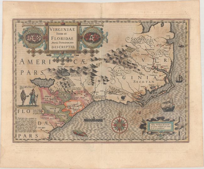
Auction 174, Lot 157
Subject: Colonial Southeastern United States
Hondius, Jodocus
Virginiae Item et Floridae Americae Provinciarum, Nova Descriptio, 1613
Size: 19 x 13.4 inches (48.3 x 34 cm)
Estimate: $1,800 - $2,100
A Seminal Map of the Southeast and Early American Cartography
Sold for: $1,000
Closed on 9/11/2019
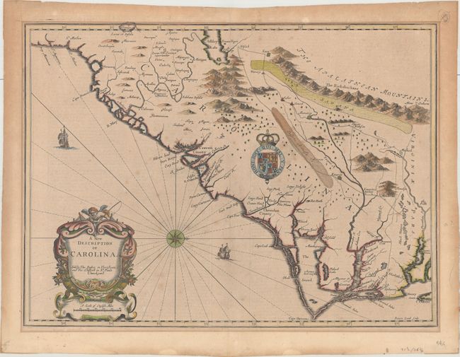
Auction 174, Lot 159
Subject: Colonial Southeastern United States
Speed/Lamb
A New Description of Carolina, 1676
Size: 20.1 x 14.8 inches (51.1 x 37.6 cm)
Estimate: $3,000 - $3,750
Speed's Map of the Carolinas Based Upon the Lords Proprietor's Map
Sold for: $2,000
Closed on 9/11/2019
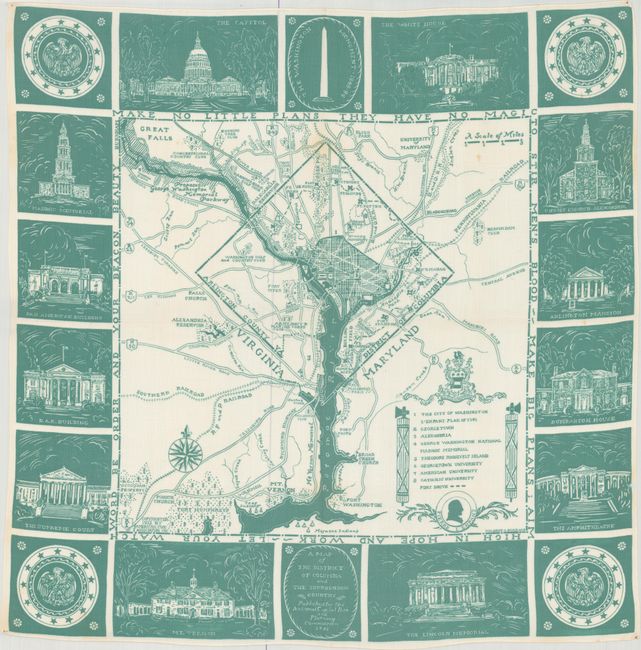
Auction 174, Lot 207
Subject: Washington, D.C.
A Map of the District of Columbia and the Surrounding Country, 1933
Size: 25.9 x 25.9 inches (65.8 x 65.8 cm)
Estimate: $550 - $750
Uncommon Handkerchief Map of DC Based on Original L'Enfant Plan
Unsold
Closed on 9/11/2019
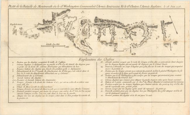
Auction 174, Lot 230
Subject: Monmouth, New Jersey
Plan de la Bataille de Montmouth ou le Gl. Washington Commandait l'Armee Americaine et le Gl. Clinton l'Armee Anglaise, le 28 Juin 1778, 1782
Size: 15.4 x 8.1 inches (39.1 x 20.6 cm)
Estimate: $1,000 - $1,300
An Important Battle Plan of the American Revolution
Sold for: $700
Closed on 9/11/2019
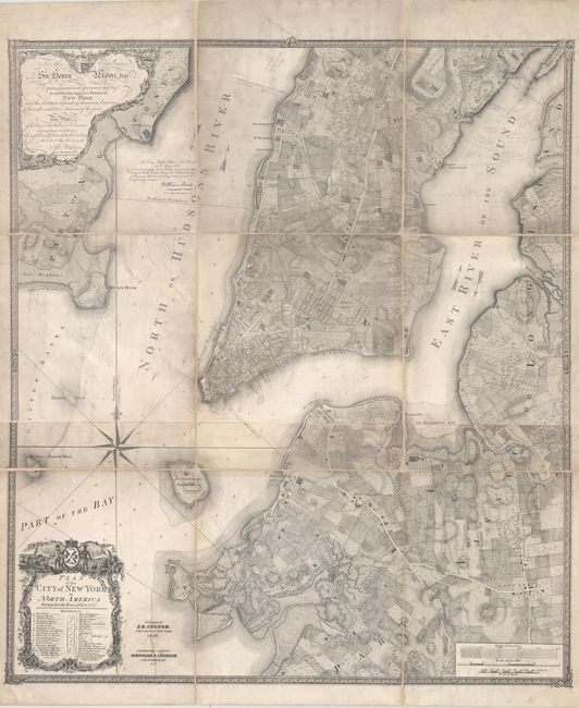
Auction 174, Lot 235
Subject: New York City, New York
Colton, Joseph Hutchins
Plan of the City of New York in North America Surveyed in the Years 1766 & 1767, 1853
Size: 35.3 x 40.2 inches (89.7 x 102.1 cm)
Estimate: $2,750 - $3,500
Colton's Rare Edition of the "Ratzer Map" of New York City
Sold for: $6,500
Closed on 9/11/2019
12 lots