Showing Featured Lots(remove filter)
Filtered by Category:United States(Show All Categories)
Showing results for:Auction 158
Catalog Archive
20 lots
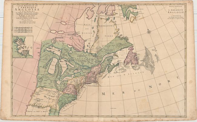
Auction 158, Lot 74
Subject: Colonial Eastern United States & Canada
Mortier, Pierre
Carte Nouvelle de l'Amerique Angloise Contenant la Virginie, Mary-Land, Caroline, Pensylvania Nouvelle Iorck, N: Iarsey N: France, et les Terres Nouvellement Decouerte..., 1700
Size: 35.8 x 23.4 inches (90.9 x 59.4 cm)
Estimate: $2,200 - $2,750
A Map Showing Fascinating Geographic Misconceptions
Unsold
Closed on 6/22/2016
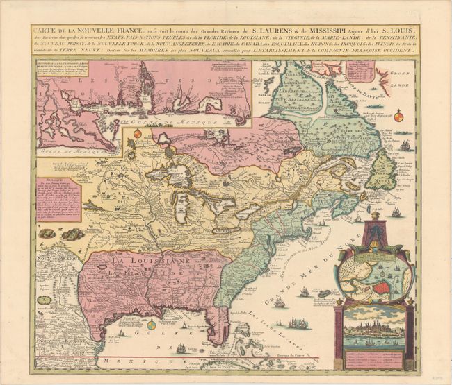
Auction 158, Lot 75
Subject: Colonial Eastern United States & Canada
Fer, Nicolas de
Carte de la Nouvelle France, ou Se Voit le Cours des Grandes Rivieres de S. Laurens & de Mississipi, Aujour d'hui S. Louis…, 1719
Size: 21.7 x 19.6 inches (55.1 x 49.8 cm)
Estimate: $2,750 - $3,500
Striking Map of French Colonial Possessions
Sold for: $2,100
Closed on 6/22/2016
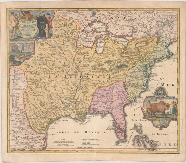
Auction 158, Lot 76
Subject: Colonial Eastern United States & Canada
Homann, Johann Baptist
Amplissimae Regionis Mississipi seu Provinciae Ludovicianae a R.P. Ludovico Hennepin Francisc Miss in America Septentrionali Anno 1687..., 1720
Size: 22.6 x 19.1 inches (57.4 x 48.5 cm)
Estimate: $1,800 - $2,200
Striking Map of Colonial America with Buffalo Vignette
Sold for: $2,300
Closed on 6/22/2016
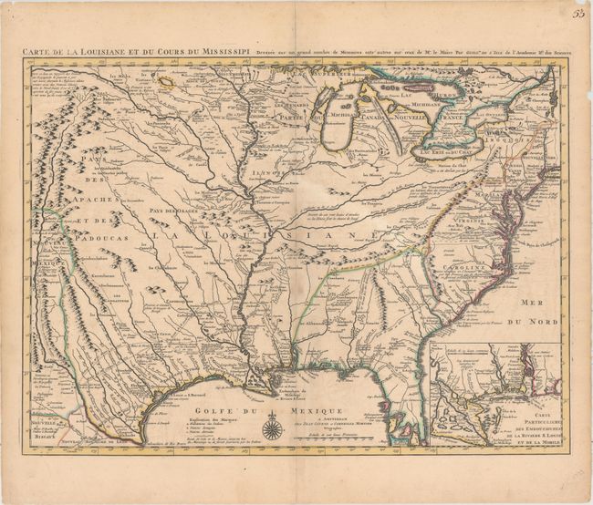
Auction 158, Lot 86
Subject: Colonial Eastern United States, Louisiana Territory
Delisle/Covens & Mortier
Carte de la Louisiane et du Cours du Mississipi Dressee sur un Grand Nombre de Memoires Entr' Autres sur Ceux de Mr. le Maire..., 1730
Size: 23.6 x 17.3 inches (59.9 x 43.9 cm)
Estimate: $2,750 - $3,500
Delisle's Influential Map of the Louisiana Territory
Sold for: $2,000
Closed on 6/22/2016
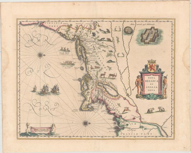
Auction 158, Lot 88
Subject: Colonial New England & Mid-Atlantic United States
Blaeu, Willem
Nova Belgica et Anglia Nova, 1640
Size: 19.9 x 15.3 inches (50.5 x 38.9 cm)
Estimate: $2,750 - $3,500
Important Map of Colonial New England and the Mid-Atlantic in Full Original Color
Unsold
Closed on 6/22/2016
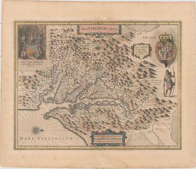
Auction 158, Lot 94
Subject: Colonial Mid-Atlantic United States
Hondius, Henricus
Nova Virginiae Tabula, 1636
Size: 19.5 x 15.1 inches (49.5 x 38.4 cm)
Estimate: $2,000 - $2,300
One of the Most Important 17th Century Maps of the Chesapeake Bay
Unsold
Closed on 6/22/2016
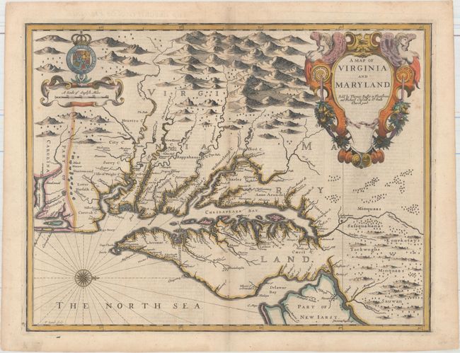
Auction 158, Lot 95
Subject: Colonial Mid-Atlantic United States
Speed/Lamb
A Map of Virginia and Maryland, 1676
Size: 19.4 x 14.9 inches (49.3 x 37.8 cm)
Estimate: $4,750 - $6,000
The First Printed Map to Draw Upon the Legendary Herrman Map of the Chesapeake Bay
Unsold
Closed on 6/22/2016
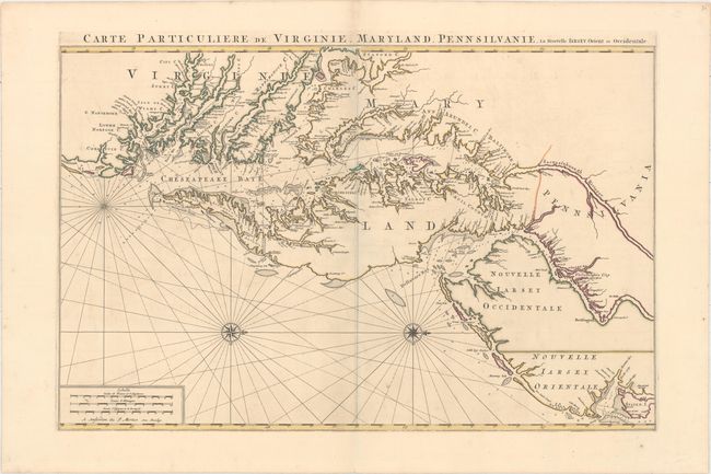
Auction 158, Lot 96
Subject: Colonial Mid-Atlantic United States
Jaillot/Mortier
Carte Particuliere de Virginie, Maryland, Pennsilvanie, la Nouvelle Iarsey. Orient et Occidentale, 1700
Size: 31.8 x 20.6 inches (80.8 x 52.3 cm)
Estimate: $6,000 - $7,500
One of the Most Beautiful Charts of Maryland and the Chesapeake Bay
Unsold
Closed on 6/22/2016
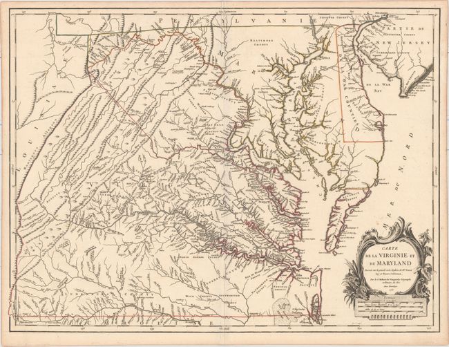
Auction 158, Lot 98
Subject: Colonial Mid-Atlantic United States
Robert de Vaugondy, Didier
Carte de la Virginie et du Maryland Dressee sur la Grande Carte Angloise de Mrs. Josue Fry et Pierre Jefferson..., 1755
Size: 25.4 x 19.1 inches (64.5 x 48.5 cm)
Estimate: $2,750 - $3,500
First State of Robert de Vaugondy's Essential Map of Virginia and Maryland
Sold for: $2,000
Closed on 6/22/2016
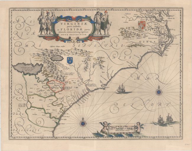
Auction 158, Lot 105
Subject: Colonial Southeastern United States
Blaeu, Willem
Virginiae Partis Australis, et Floridae Partis Orientalis, Interjacentiumq Regionum Nova Descriptio, 1643
Size: 19.6 x 15.2 inches (49.8 x 38.6 cm)
Estimate: $1,600 - $1,900
Blaeu's Decorative Map of the Southeast
Sold for: $1,200
Closed on 6/22/2016
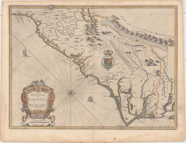
Auction 158, Lot 106
Subject: Colonial Southeastern United States
Speed/Lamb
A New Description of Carolina, 1676
Size: 20 x 14.8 inches (50.8 x 37.6 cm)
Estimate: $4,000 - $5,000
Speed's Map of the Carolinas Based Upon the Lords Proprietor's Map
Unsold
Closed on 6/22/2016
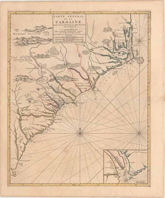
Auction 158, Lot 107
Subject: Colonial Southeastern, North Carolina, South Carolina
Mortier, Pierre
Carte General de la Caroline Dresse sur les Memoires le Plus Nouveaux..., 1700
Size: 18.3 x 22.2 inches (46.5 x 56.4 cm)
Estimate: $3,000 - $3,750
The First Map of the Carolinas Published Outside of England
Sold for: $2,000
Closed on 6/22/2016
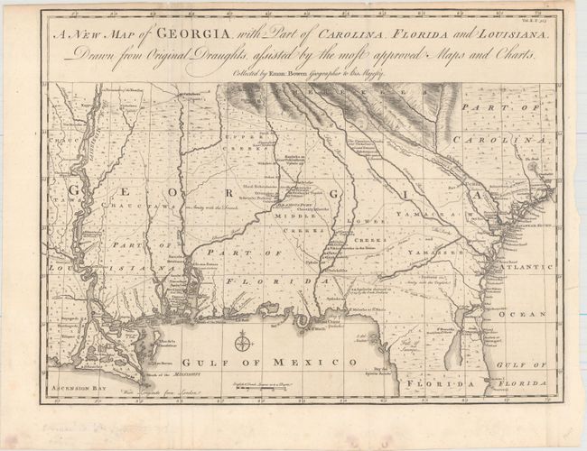
Auction 158, Lot 108
Subject: Colonial Southeastern United States
Bowen, Emanuel
A New Map of Georgia, with Part of Carolina, Florida and Louisiana. Drawn from Original Draughts, Assisted by the Most Approved Maps and Charts, 1748
Size: 18.8 x 14.3 inches (47.8 x 36.3 cm)
Estimate: $3,000 - $3,750
Important Map of the Georgia Colony
Unsold
Closed on 6/22/2016
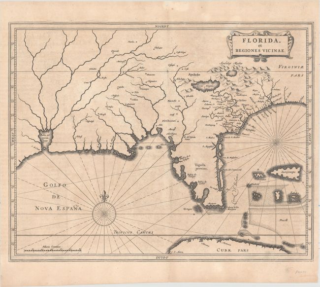
Auction 158, Lot 110
Subject: Colonial Southern United States
Gerritsz/De Laet
Florida, et Regiones Vicinae, 1630
Size: 14 x 11.3 inches (35.6 x 28.7 cm)
Estimate: $3,000 - $3,750
De Laet's Important Map of the South
Unsold
Closed on 6/22/2016
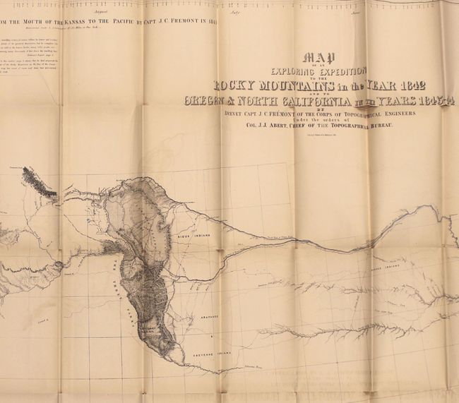
Auction 158, Lot 118
Subject: Western United States
Fremont/Preuss
Map of an Exploring Expedition to the Rocky Mountains in the Year 1842 and to Oregon & North California in the Years 1843-44 [with] Report of The Exploring Expedition to the Rocky Mountains…, 1845
Size: 51 x 30.5 inches (129.5 x 77.5 cm)
Estimate: $1,800 - $2,200
Fremont's Large Map of the American West
Unsold
Closed on 6/22/2016
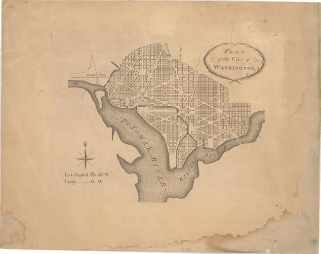
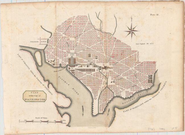
Auction 158, Lot 128
Subject: Washington, D.C.
Thackara, James
Plan of the City of Washington, 1792
Size: 10.4 x 8.5 inches (26.4 x 21.6 cm)
Estimate: $5,000 - $6,500
Very Rare - The First Printed Plan of Washington
Sold for: $3,750
Closed on 6/22/2016
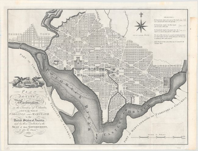
Auction 158, Lot 129
Subject: Washington, D.C.
Russell, John C.
Plan of the City of Washington, in the Territory of Columbia, Ceded by the States of Virginia and Maryland to the United States of America, and by Them Established as the Seat of Their Government, After the Year 1800, 1795
Size: 20.9 x 15.9 inches (53.1 x 40.4 cm)
Estimate: $2,400 - $3,000
Rare, Early Large Format Map of Washington D.C.
Unsold
Closed on 6/22/2016
Auction 158, Lot 130
Subject: Washington, D.C.
Plan of the City of Washington, 1805
Size: 10.6 x 8.3 inches (26.9 x 21.1 cm)
Estimate: $2,000 - $2,500
Rare Scottish Plan of Washington
Unsold
Closed on 6/22/2016
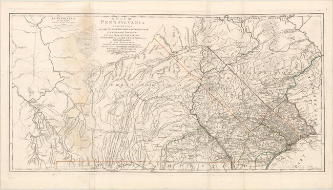
Auction 158, Lot 145
Subject: Pennsylvania, Revolutionary War
Le Rouge, George Louis
La Pensilvanie en Trois Feuilles Traduite des Meilleures Cartes Anglaises / A Map of Pennsylvania Exhibiting Not Only the Improved Parts of That Province, but Also Its Extensive Frontiers..., 1778
Size: 52.1 x 26.3 inches (132.3 x 66.8 cm)
Estimate: $4,500 - $5,500
Scarce French Edition of an Important Revolutionary War Map
Sold for: $2,000
Closed on 6/22/2016
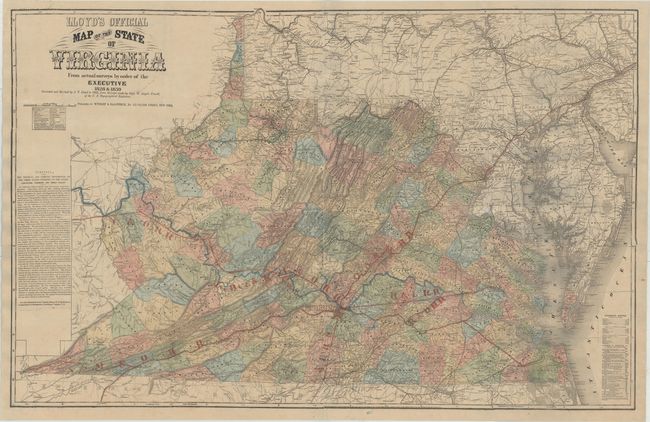
Auction 158, Lot 151
Subject: Virginia
Lloyd, James T.
Lloyd's Official Map of the State of Virginia From Actual Surveys by Order of the Executive 1828 & 1859..., 1862
Size: 47.3 x 30.4 inches (120.1 x 77.2 cm)
Estimate: $2,750 - $3,500
Extremely Rare Promotional Map with Railroad Overprint
Unsold
Closed on 6/22/2016
20 lots