Showing Featured Lots(remove filter)
Filtered by Category:Canada(Show All Categories)
Showing results for:Auction 171
Catalog Archive
4 lots
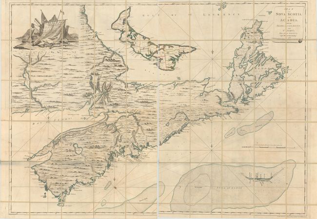
Auction 171, Lot 119
Subject: Canadian Maritimes
Montresor, John
[On 4 Joined Sheets] Map of Nova Scotia, or Acadia; with the Islands of Cape Breton and St. John's, from Actual Surveys... , 1768
Size: 56.4 x 40.6 inches (143.3 x 103.1 cm)
Estimate: $6,000 - $7,500
Montresor's Colossal Map of the Maritimes
Sold for: $6,000
Closed on 2/6/2019
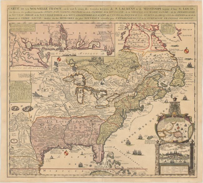
Auction 171, Lot 123
Subject: Colonial Eastern United States & Canada
Fer, Nicolas de
Carte de la Nouvelle France, ou se voit le Cours des Grandes Rivieres de S. Laurens & de Mississipi Aujour d'hui S. Louis, aux Environs des-quelles se Trouvent les Etats, Pais, Nations, Peuples &c..., 1719
Size: 21.4 x 19.5 inches (54.4 x 49.5 cm)
Estimate: $2,300 - $2,750
Striking Map of French Colonial Possessions
Sold for: $1,700
Closed on 2/6/2019
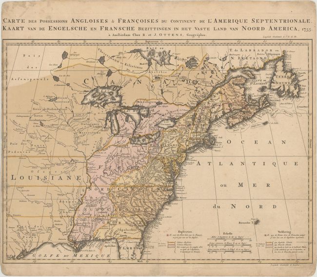
Auction 171, Lot 124
Subject: Colonial Eastern United States & Canada
Ottens, Reiner and Joshua
Carte des Possessions Angloises & Francoises du Continent de l'Amerique Septentrionale / Kaart van de Engelsche en Fransche Bezittingen in het Vaste Land van Noord America, 1755
Size: 22.4 x 16.3 inches (56.9 x 41.4 cm)
Estimate: $2,000 - $2,300
Dutch Version of an Important Map Showing Territorial Claims at the Outset of the French and Indian War
Unsold
Closed on 2/6/2019
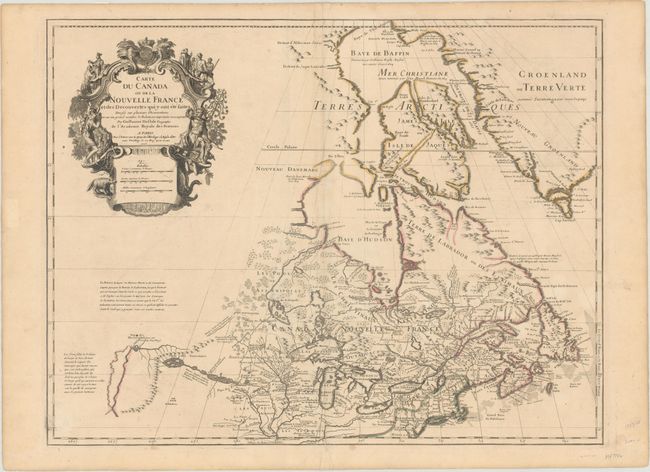
Auction 171, Lot 130
Subject: Colonial Northeastern United States & Canada, Great Lakes
Delisle, Guillaume
Carte du Canada ou de la Nouvelle France et des Decouvertes qui y ont ete Faites Dressee sur Plusieurs Observations..., 1703
Size: 25.6 x 19.6 inches (65 x 49.8 cm)
Estimate: $2,200 - $2,500
Delisle's Seminal Map of Canada and the Great Lakes
Sold for: $1,200
Closed on 2/6/2019
4 lots