Showing Featured Lots(remove filter)
Filtered by Category:Canada(Show All Categories)
Showing results for:Auction 160
Catalog Archive
7 lots
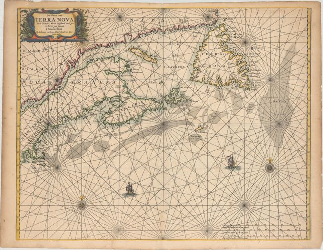
Auction 160, Lot 132
Subject: Canadian Maritimes & New England
Loon, Jan van
Pas-caerte van Terra Nova, Nova Francia, Nieuw Engeland en de Grote Rivier van Canada, 1666
Size: 21.2 x 16.8 inches (53.8 x 42.7 cm)
Estimate: $3,500 - $4,500
Very Influential Dutch Sea Chart of the Canadian Maritimes
Sold for: $1,900
Closed on 11/16/2016
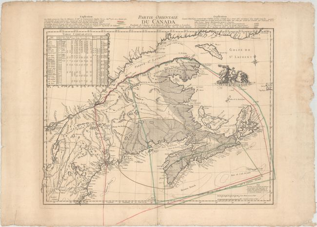
Auction 160, Lot 137
Subject: Colonial Northeastern United States & Canada
Le Rouge, George Louis
Partie Orientale du Canada Traduitte de l'Anglois de la Carte de Jefferys Publiee a Londres..., 1755
Size: 24.1 x 18.6 inches (61.2 x 47.2 cm)
Estimate: $950 - $1,200
Map Depicting French and British Claims in the Canadian Maritimes
Sold for: $600
Closed on 11/16/2016
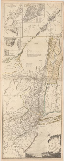
Auction 160, Lot 139
Subject: Colonial Northeastern United States & Quebec
Holland/Pownal
The Provinces of New York and New Jersey; with Part of Pensilvania, and the Province of Quebec, 1776
Size: 21.3 x 52.9 inches (54.1 x 134.4 cm)
Estimate: $5,500 - $7,000
Thomas Jefferys' Important Revolutionary War Period Map
Sold for: $3,500
Closed on 11/16/2016
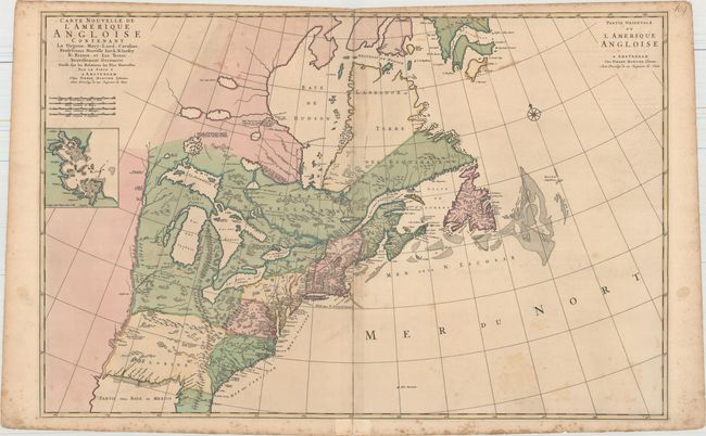
Auction 160, Lot 145
Subject: Colonial Eastern United States & Canada
Mortier, Pierre
Carte Nouvelle de l'Amerique Angloise Contenant la Virginie, Mary-Land, Caroline, Pensylvania Nouvelle Iorck, N: Iarsey N: France, et les Terres Nouvellement Decouerte..., 1700
Size: 35.8 x 23.4 inches (90.9 x 59.4 cm)
Estimate: $2,000 - $2,300
A Map Showing Fascinating Geographic Misconceptions
Sold for: $1,200
Closed on 11/16/2016
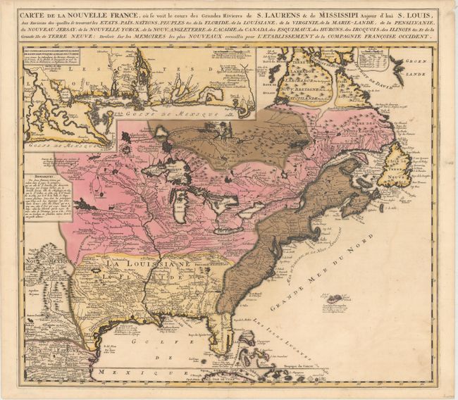
Auction 160, Lot 146
Subject: Colonial Eastern United States & Canada
Ottens/De Fer
Carte de la Nouvelle France, ou se Voit le Cours des Grandes Rivieres de S. Laurens & de Mississipi Aujour d'hui S. Louis, aux Environs des-quelles se Trouvent les Etats, Pais, Nations, Peuples &c..., 1719
Size: 21.5 x 19.5 inches (54.6 x 49.5 cm)
Estimate: $2,300 - $2,750
Reduced Version of De Fer's Influential Map of French Possessions in North America
Sold for: $1,700
Closed on 11/16/2016
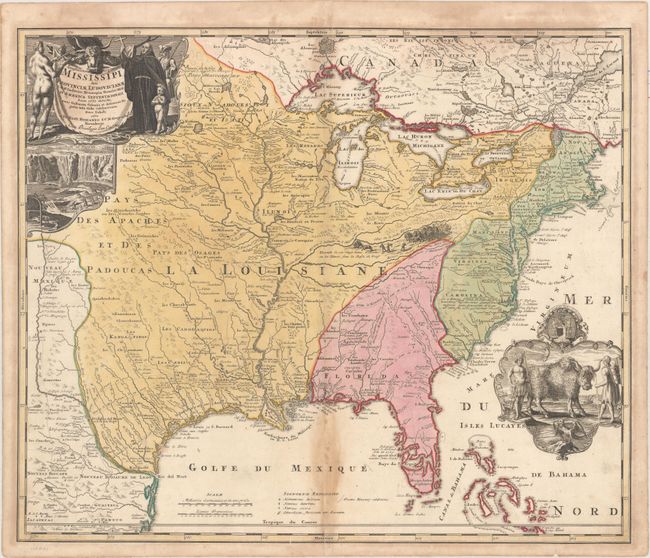
Auction 160, Lot 147
Subject: Colonial Eastern United States & Canada
Homann, Johann Baptist
Amplissimae Regionis Mississipi seu Provinciae Ludovicianae a R.P. Ludovico Hennepin Francisc Miss in America Septentrionali Anno 1687..., 1720
Size: 22.6 x 19.1 inches (57.4 x 48.5 cm)
Estimate: $1,700 - $2,000
Striking Map of Colonial America with Buffalo Vignette
Sold for: $1,400
Closed on 11/16/2016
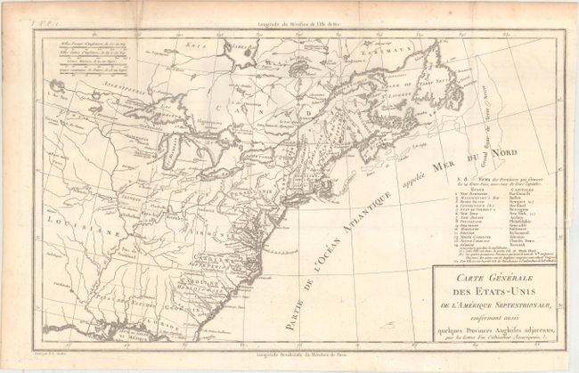
Auction 160, Lot 150
Subject: Eastern United States & Canada
Crevecoeur, Michel Guillaume De
Carte Generale des Etats-Unis de l'Amerique Septentrionale, Renfermant Aussi Quelques Provinces Angloises Adjacentes..., 1787
Size: 16.7 x 10.1 inches (42.4 x 25.7 cm)
Estimate: $800 - $1,000
One of the Earliest Maps to Name Franklinia
Sold for: $600
Closed on 11/16/2016
7 lots