Subject: Atlas
Period: 1851 (published)
Publication:
Color: Hand Color
Size:
10.7 x 14.5 inches
27.2 x 36.8 cm
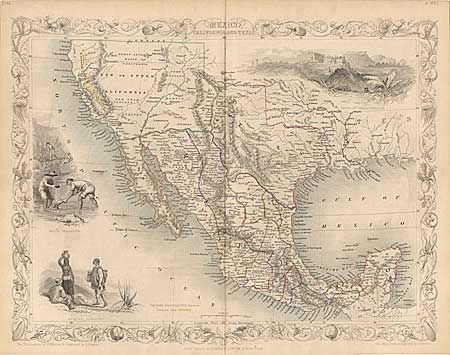
Tallis' famous atlas complete with all 80 maps, however many were originally bound out of order per the Listing of Maps. The Mexico, California and Texas map is the Gold Rush version with the added vignette titled Gold Washing and the gold region of California identified with yellow hand color along the Rivers Sacramento and San Joaquin. All of the maps were drawn and engraved by John Rapkin, while the surrounding vignettes were drawn by other artists and engravers. The maps are in original outline color and the vignettes and borders are uncolored, as issued. Lightly toned throughout, with occasional light foxing. The frontispiece is badly stained and the title page has more foxing than the balance of maps. All maps are crisp impression with good color. Edited by R. Montgomery Martin, Esq. and published by J & F. Tallis, London & New York. 314pp with index. Cloth with leather spine, marbled end-papers. Top cover and first two end-papers detached, cover tattered. In need of a book binders care, but certainly worthy. A most desirable and complete atlas.
References:
Condition: B
Top cover and first two end-papers detached, cover tattered. In need of a book binders care, but certainly worthy. A most desirable and complete atlas.