Subject: Northwestern Oregon
Period: 1851 (dated)
Publication:
Color: Black & White
Size:
27.2 x 17.2 inches
69.1 x 43.7 cm
The Office of Coast Survey is the oldest U.S. scientific organization, dating from 1807 when Congress directed that a "survey of the coast" be carried out. By 1836, it was called the U.S. Coast Survey and in 1878, the name was changed to the U.S. Coast and Geodetic Survey. Today the Office of Coast Survey is a division of the National Oceanic and Atmospheric Administration NOAA.
The survey teams, composed of civilians as well as Army and Naval officers, charted the nation's waterways and produced a wide array of reports, survey charts, hydrographic studies of tides and currents, astronomical studies and observations, and coastal pilots. These charts are an important record of the changing nature of the nation's coastlines. In additional to coastal charts, the U.S. Coast and Geodetic Survey produced land sketches, Civil War battle maps, and the early aeronautical charts.
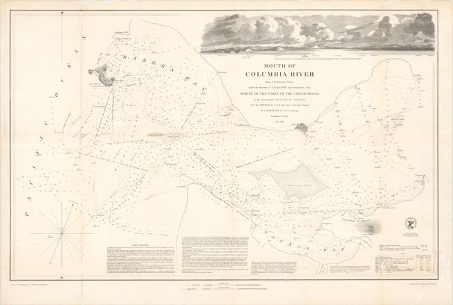
A detailed chart of the mouth of the Columbia River, stretching from Pacific City (Fort Canby), Washington to Astoria, Oregon. The chart highlights several treacherous regions in the river including the large Columbia Bar (Middle Sands) off of Pacific City, breakers, spits, and two areas noted as "Bare at Low Water." The river is filled with other navigational details including soundings, currents, bottom types, and more. Text at bottom provides additional detail on sailing directions and tides. An attractive illustration of the river's mouth fills the upper section of the chart. Surveyed by W.P. McArthur and W.A. Bartlett under the direction of Superintendent A.D. Bache. Engraved by W. Smith and E.F. Woodward.
References:
Condition: B
Issued folding on a bright sheet that has been flattened and backed with tissue to reinforce and repair a number of separations along the folds. There is some image loss along the left vertical fold with other minor losses in the illustration at top right and the tide chart at bottom right.