Subject: World
Period: 1676 (dated)
Publication:
Color: Hand Color
Size:
21.4 x 17.1 inches
54.4 x 43.4 cm
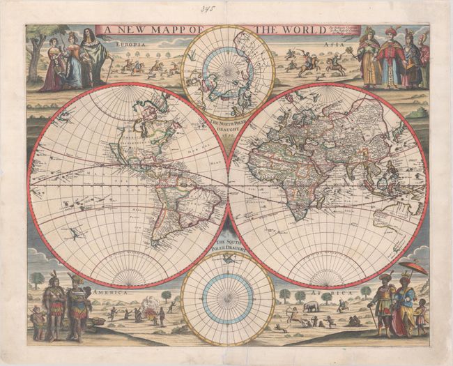
This extremely rare, and superbly embellished double-hemisphere map was created by Robert Greene, a publisher and mapseller of London. Although the four hemispheres are closely copied from Nicholas Visscher's 1658 map (Orbis Terrarum Nova et Accuratissima Tabula), the decorative surround is unique. The four corners represent costumed figures from each of the four continents and vignettes of hunting. At top left, looming over the western hemisphere, are King Charles II and Catherine of Braganza with two attendants, representing Europe. A stag hunt enfolds in the background, in contrast to the less civilized scenes accompanying the other continents. In Asia a battle on horseback is depicted adjacent to several finely enrobed people of Asia. The people representing America and Africa are decidedly less civilized, many of whom are scantily clad or completely naked. In America a regal couple wear feathers and stand before an alligator while cannibals prepare a meal in the background. In Africa, the scene includes a centaur and naked children hunting, as well as a lion and an elephant.
Cartographically, the map is nearly identical to Visscher's map, which itself was largely based on Johannes Blaeu's 1648 wall map. In the eastern hemisphere, the eastern coastline of Asia is severely truncated, Korea appears as a narrow peninsula, and the mythical Lake Chaimay appears in western China with five rivers flowing south. Australia is partially mapped based on the Dutch explorations in the region. In the western hemisphere, the island of California is shown with a flat northern coast, the northern part of which is labeled Nova Albion and with Pt. Sr. Franco Draco located. The small partial coastline of Anian appears on the northwest coast of North America. In the south Pacific, the explorations of Tasman are evident, where two coastlines of New Zealand are delineated.
However, Greene makes significant updates to the Atlantic Coast of North America, which reflect British interests in the region. A number of place names are added along the coast, including Maryland, Carolina, New Jersey, Long Island, Boston, Nantock, and C. Cod. In addition, Greene departs from the typical Dutch depiction of the Great Lakes in which there was one large lake that was open-ended to the west. Instead, this one lake, which is connected to the St. Lawrence River, is fully delineated in the west and is labeled Higonatans Lake, a name which appears to be unique to this map.
This map is extremely rare. We are only aware of a handful of examples in public institutions and 3 other examples having been offered at auction in the last 40 years, with the most recent one selling at Bonham's for $11,950 in 2006.
References: Shirley #476.
Condition: B+
A sharp impression on a bright sheet with marginal soiling and some minute worm holes. There are professional repairs to some small chips along the edges of the sheet, a centerfold separation in the South Polar hemisphere, and several short edge tears, two of which enter less than 1" into image at bottom center. The edges of the sheet have been archivally reinforced with thin tissue on verso.