Subject: South Pacific Ocean & South America
Period: 1775 (dated)
Publication: The American Atlas
Color: Hand Color
Size:
43.8 x 16.9 inches
111.3 x 42.9 cm
Thomas Jefferys was one of the most important English map publishers of the 18th century. His work included prints and maps of locations around the world, but his most notable maps are of North America and the West Indies. He began his career in the map trade in the early 1730s, working as an engraver for a variety of London publishers, and eventually setting up his own shop. In 1746, he was appointed Geographer to the Prince of Wales, and in 1760 he became Geographer to the King. These titles granted access to manuscripts and cartographic information held by the government. In the early 1760s he embarked on an ambitious project to produce a series of English county maps based on new surveys, but ran out of money and filed for bankruptcy in 1766. He then partnered with London publisher Robert Sayer, who reissued many of Jefferys plates and continued to issue new editions after Jefferys' death in 1771. Jefferys' American Atlas and the accompanying West-India Atlas, published post posthumously, are considered his most important cartographic works.
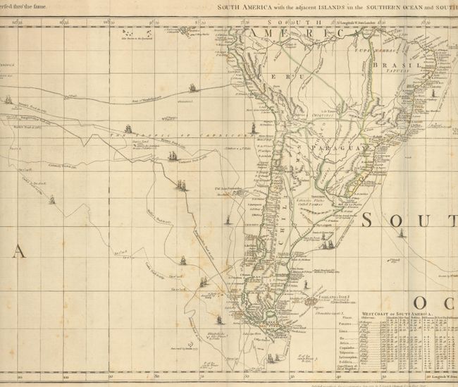
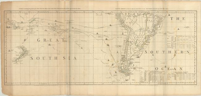
This is the bottom portion of Thomas Jefferys' large and important three-part map of the Americas, compiled in 1753 by Braddock Meade, one of the most intriguing figures in British cartographic history as well as an extremely gifted mapmaker. Working under the alias John Green after serving time for defrauding an Irish heiress, Meade compiled many of Jefferys' most important maps. The portion here focuses on the South Pacific Ocean, here called the Great South Sea, and South America. Sheet V, Chart Containing the Greater Part of the South Sea to the South of the Line, with the Islands Dispersed Thro' the Fame, has been updated in its fourth state to include the tracks of Byron, Carteret, Wallis, Bougainville, and Cook in addition to Mendana and Tasman. Imaginary Isles of Solomon are traced with dotted lines, and New Zealand has taken shape as two distinct islands. Sheet VI, South America with the Adjacent Islands in the Southern Ocean and South Sea, includes the tracks of Vespucci in 1502, Dr. Halley, Anson, and Narborough. Pepy's Imaginary Isle and the Elizabethides and another stretch of coast discovered by Drake are identified. Inland, the mythical lake Xarayes is located. Tables at right show the variations in latitude and longitude between Jefferys' chart and those of Bellin and D'Anville. Two joined sheets, as issued.
References: Ristow pp. 31-32; Schwartz & Erhrenberg, p.158-59; Stevens & Tree #4-Sheet V & VI (d)
Condition: B
A crisp impression with contemporary outline color on paper with a Strasbourg lily watermark. There is light foxing and soiling, extraneous creasing around the folds, and light uneven toning at left. An archivally repaired edge tear enters 2.25" into map image at left, with remnants of an old non-archival tape repair on verso. Other edge tears and fold separations are confined to the blank margins. (The bluish hue along the fold lines in the image is caused by our scanner and is not on the physical map.)