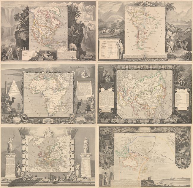
Subject: World & Continents, Title Page
Period: 1856 (published)
Publication: Atlas National Illustre
Color: Hand Color
Victor Levasseur's "Atlas National Illustre" and "Atlas Universel Illustre" are among the last decorative atlases published. The maps are all lavishly illustrated with scenes of the countryside, products and activities indigenous to the region.
This lot collects six terrific maps and a title page from Levasseur's decorative atlases. Each map is surrounded in an elaborately engraved border containing vignettes representing the region in views, natives, plants, animals, explorers, etc. The illustrations on the maps of the continents were drawn by Raimond Bonheur, father of the famous painter Rosa Bonheur, who trained under her father.
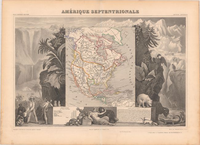
A. Amerique Septentrionale (16.9 x 10.9"). This richly engraved map of North America shows the United States' claims into present-day Canada reflecting the Oregon boundary dispute. There is a late depiction of the Republic of Texas in its smaller configuration, and Mexico's northern border is drawn according to the Treaty of 1819 (here misprinted as 1810). Russia is in control of Alaska. The map is surrounded by beautifully engraved scenes of North and Central America including wildlife, a ship stranded in the polar sea, and a Mayan temple.
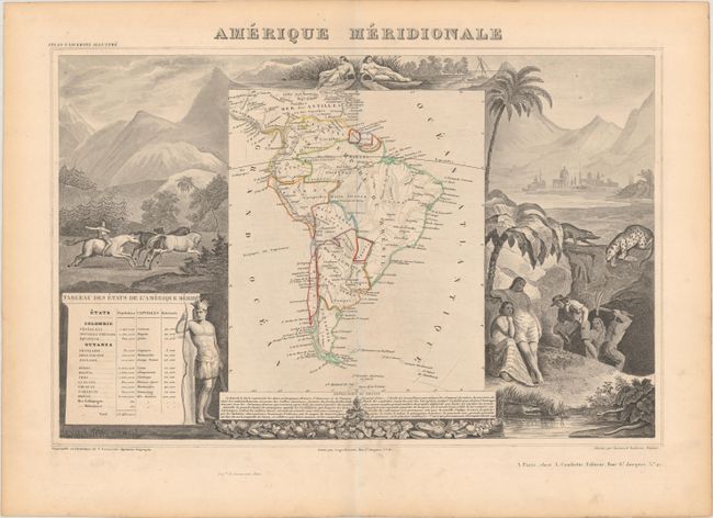
B. Amerique Meridionale (16.6 x 10.6"). The map shows political divisions in outline color, with good detail of rivers and topography. It is surrounded by steel engraved scenes including horses, Indians, jaguars, tapirs, and mining as well as female personifications at the top representing the Amazon and La Plata Rivers.
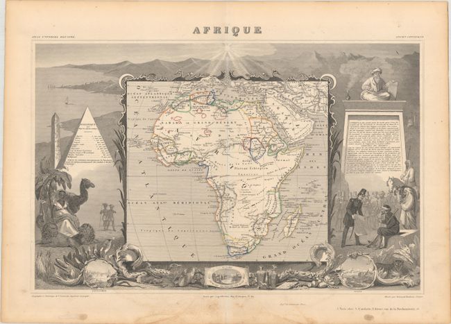
C. Afrique (17.1 x 11.0"). This map of the continent shows the colonial possessions and major tribal kingdoms. The interior is mostly void of detail, with the exception of the mythical Monts de la Lune, or Mountains of the Moon in the center of the continent. These legendary mountains were long thought to be the source for the Nile, dating back to Ptolemy. Stanley traced a fluvial connection from the Nile back to a mysterious snowy mountain range in Central Africa in 1888, dubbing the mountains Ruwenzori and proclaiming them the Nile source that Ptolemy described. The map is surrounded by steel-engraved scenes of the pyramids, wild animals, natives, the French army in Algeria, and vignettes of Alexandria, Cairo, and Algiers. The map also includes population statistics from the major countries and French text describing the continent and the engravings surrounding the map. Reference: Norwich #140.
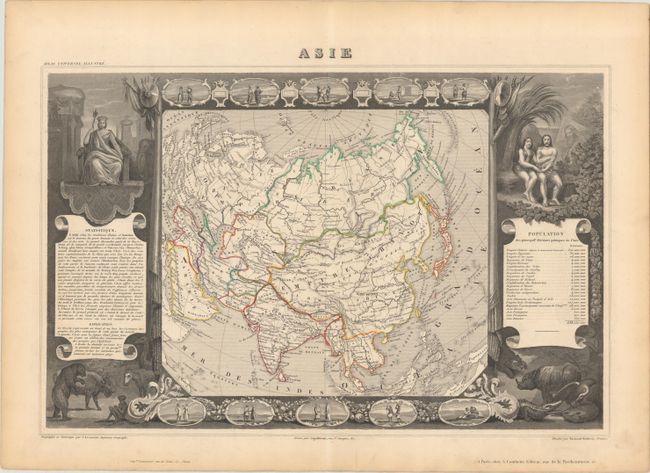
D. Asie (17.0 x 10.9"). This terrific map of the Asian continent is surrounded by steel engraved vignettes depicting the various peoples of Asia in costume, several exotic animals, and a seated portrait of Adam and Eve. The map graphically depicts the Great Wall of China and extends to include Sumatra and Borneo. Iran is Perse, Thailand is Siam, and Sri Lanka is Ceylan. There is an interesting population chart at right totaling only 638,550,000 for the entire continent.
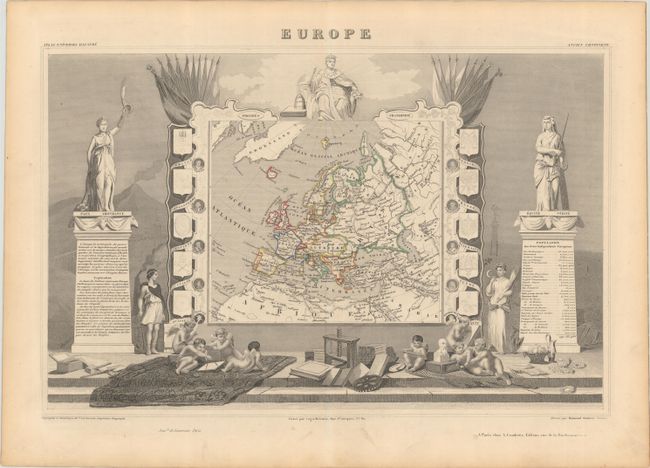
E. Europe (17.1 x 10.9"). Very handsome map of Europe that includes Greenland, Iceland, and the Arctic Circle. The surrounding engravings make this one of the most decorative maps of the 19th century. The map itself is framed by medallion portraits and coats of arms down each side, and is set against a background of statues and allegorical figures, with a large group of adorable cherubs engaged in academic pursuits filling the foreground.
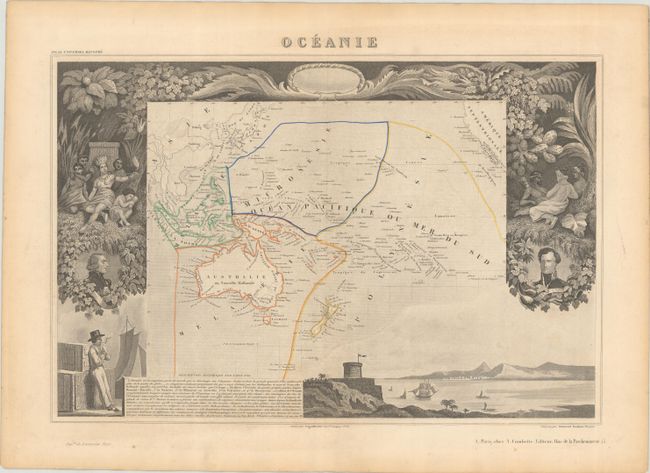
F. Oceanie (16.4 x 10.9"). This map covers the entire South Pacific including Australia, New Zealand, and Southeast Asia. The map is surrounded by beautifully rendered steel-engraved scenes that feature the natives of the region, portraits of French explorers, a harbor vignette, along with French text describing the region.
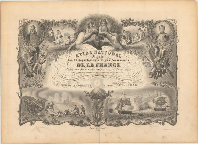
G. Atlas National Illustre des 86 Departements et des Possessions de la France... (16.5 x 11.5"). Attractive title page from one of the last decorative atlases of the nineteenth century. The steel engraved scenes surrounding the script title are enclosed in a border of tree branches and grapevines engraved by Eugene Duchez. There are infantry and naval battle scenes, portraits, armor and weaponry, ballooning, an early railroad engine, a river god and goddess, and a group of cherubs engaged in a variety of scientific and artistic pursuits.
References:
Condition:
Maps are all fine impressions with contemporary outline color. The majority are in A condition with marginal toning and soiling, except for the Africa and Oceania maps, which are in B+ condition with light soiling. Title page is in B+ condition with light soiling, a few small spots, and an old stamp on verso.