Subject: North Pacific Ocean
Period: 1785 (circa)
Publication: A New Authentic and Complete Collection of Voyages Round the World
Color: Black & White
Captain James Cook (1728-1779) is best known for his three voyages to the Pacific (1768-71; 1772-75; and 1776-79). His discoveries radically changed the western understanding of the world in the late 18th century. He was the first to circumnavigate and chart New Zealand and provided the earliest European accounts of exploration along the eastern coast of Australia and the Hawaiian Islands. On February 14th, 1779, he was killed on Hawaii after attempting to kidnap the chief of the island.
Many contemporary accounts of Cook’s voyages, including charts and engravings, appeared in the late 18th century. The first official account of Cook’s first voyage was published in 1773 by John Hawkesworth in Volumes II and III of An Account of the Voyages Undertaken by the Order of His Present Majesty for Making Discoveries in the Southern Hemisphere... William Strahan and Thomas Cadell published the first official accounts of the second and third voyages in 1777 and 1784. Accounts of his exploration were subsequently translated into French, German, and Dutch.
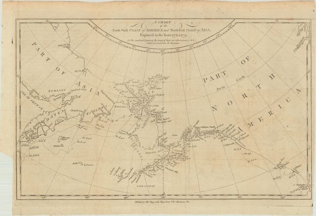
A. A Chart of the North West Coast of America and North East Coast of Asia, Explored in the Years 1778 & 1779..., (14.0 x 8.6"). This charts traces Captain Cook's route through Alaska, the Bering Strait, and Kamchatka. It was drawn by Lt. Roberts, Master mate on the Resolution under Cook. It depicts the coastlines of Alaska, British Columbia, and Russia; a note explains that part of the information on the map was obtained from a manuscript chart received from the Russians. The ship's route is traced with navigational information including soundings. The map's detail is focused on Cook's third and final expedition (1776-79), when he traveled up the northern reach of the Pacific in search of a Northwest Passage. His routes are traced and dated. Cook probed up along the Oregon coast in bad weather to Nootka Sound, where he rested and refitted his ships. They sailed forth to the Alaskan and Chukotskiy peninsulas and from there into the Bering Strait. Cook got as far north as 70° by 41° N before being forced back by the ice off Icy Cape. The expedition came south down the Russian coast and then east to Norton Sound. Cook's expedition then sailed south to Hawaii, where Cook was killed in a dispute with the natives. His second-in-command Clerke took over the expedition and they explored further in Hawaii before returning north to continue the exploration for the Northwest Passage.
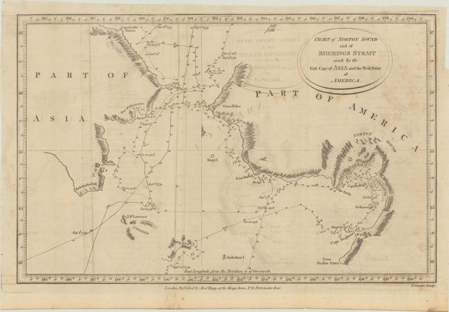
B. Chart of Norton Sound and of Bherings Strait Made by the East Cape of Asia and the West Point of America, (12.9 x 8.3"). This chart covers the area on either side of the Bering Strait including Norton Sound with the Resolution's route detailed with day-to-day notations during Cook's voyage in 1779. Details include sections of the coastline and islands with many place names, soundings and anchorages.
References: Shirley (BL Atlases) G.AND-1a #2 & #4.
Condition: B+
Issued folding with light offsetting.