Subject: Western Hemisphere - America
Period: 1774 (circa)
Publication: Geographia Antiqua in Compendium Redacta
Color: Hand Color
Size:
17.9 x 12.1 inches
45.5 x 30.7 cm
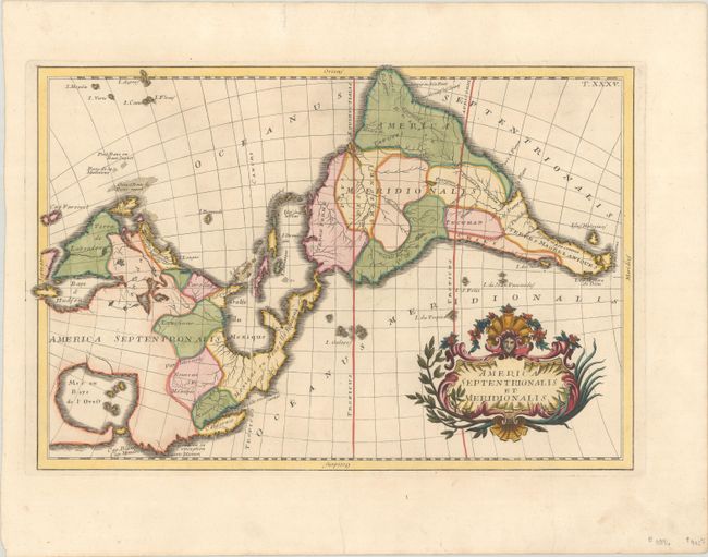
This scarce map has two unique and conspicuous features: an east-west orientation and an enormous Sea of the West in North America. There are several small islands in the Sea of the West, which has an entrance near Cap. Blanc. A number of regions are named within North America, including Carolina, Florida, Lousiana, New Mexico, New Navarre, California, and Mexico or New Spain. Santa Fe is also noted. Geography is limited to rivers, which are curiously unnamed in North America but named in South America. A decorative title cartouche fills the South Pacific Ocean.
This map was copied from Janvier-Longchamp's rare wall map of the Americas (1754), faithfully following the east-west orientation but with much simplified geography due to the reduction in size. The map was published by Giovanni Baptista Ghisius and Franciscus Tirolius in a rare edition of Christophorus Cellarius' Geographia Antiqua in Compendium Redacta, which was published well after his death. As Ghisius was also an engraver, it is possible that this map was engraved by him, although there is no engraver's signature on the map.
References: McGuirk #154; Shirley (BL Atlases) T.CELL-5a #34.
Condition: A
A crisp impression on watermarked paper.