Subject: New Mexico
Period: 1950 (circa)
Publication:
Color: Printed Color
Size:
5.5 x 8.6 inches
14 x 21.8 cm
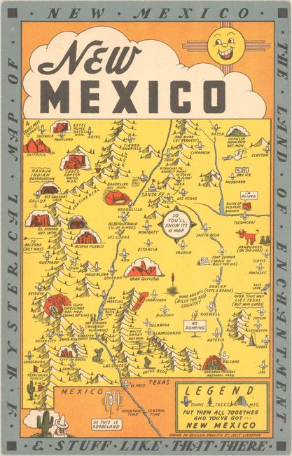
This graphic map of New Mexico was "drawn in broken English" by Jolly Lindgren. Filled with humorous text and illustrations, the map captures the charm of the state and its attractions, including Carlsbad Caverns National Park, the Petrified Forest, White Sands National Monument, Bandelier National Monument, Aztec Ruins National Monument, and Gila Cliff Dwellings National Monument with an adjacent note "Rooms 50 cents and up." There is a compass rose labeled "so you'll know it's a map" and towns are marked with a head wearing a comically-tall 10-gallon hat. The legend identifies towns, trees and mountains and indicates that if you "put them all together and you've got New Mexico." This map is printed on cardstock with "King Size Mapcard" printed on verso to allow tourists to mail this postcard to friends and family.
The Lindgren brothers of Spokane, Washington, specialized in humorous maps of state parks. The brothers founded their business in 1928 with Hjalmer (Jolly) serving as the artist and Oscar (O.S.) overseeing administration and production. They produced their first map in 1932 - Hysterical Map of the Spokane Country Slightly Cockeyed - which was designed to be "hysterical" rather than "historical." Their comical map was successful, and in 1933 others followed, including Puget Sound, Rainier National Park and Yellowstone National Park. Despite the Great Depression, tourism in National Parks increased significantly in the 1930s, and visitors were eager for souvenirs of their trips. The Lindgren brothers capitalized on this trend, producing numerous National Park maps. Beginning with the Yellowstone map, Jolly developed a standardized format with a bold blue border incorporating the title, yellow denoting land (because of Yellowstone), red for roadways, black for text, and accents of green and blue. This style and color scheme became Jolly's signature style and was continued on all of his Hysterical maps of National Parks. The Lindgren brothers had hired Ted Turner as director of sales in 1930, and his role in the business gradually evolved until he became an official partner in 1949, and the business was renamed Lindgren-Turner. After World War II, the map business declined, so the Lindgrens and Turner innovated to create souvenir decals, which becamee hugely popular. After Jolly Lindgren's death in 1952, Oscar Lindgren and Ted Turner further extended the product line to include postcards (called "King Size Mapcard").
References: Clinton (IMCOS #125) pp. 27-39; Hornsby, p. 58.
Condition: A
Very minor soiling and lightly bumped corners.