Subject: Texas, Gulf Coast
Period: 1886-99 (dated)
Publication:
Color: Black & White
Six charts showing the development of the Gulf Coast (with an emphasis on Texas) in the latter part of the 19th century:
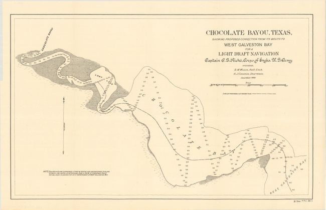
A. Chocolate Bayou, Texas, Showing Proposed Connection from Its Mouth to West Galveston Bay for a Light Draft Navigation, by U.S. Corps of Engineers, dated 1899 (19.6 x 12.0"). Extends from West Galveston Bay to Chocolate Bayou with a "Line of Proposed Cut" in the center of Chocolate Bay.
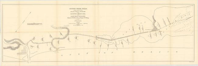
B. Oyster Creek, Texas, Showing Connection with Brazos River & Oyster Bay by the Galveston & Brazos Canal for a Light Draft Navigation, by U.S. Corps of Engineers, dated 1899 (50.8 x 15.7"). Depicts the area from Quintana to Oyster Bay with a canal connecting it to the Brazos River. Includes depths of the canal at various points.
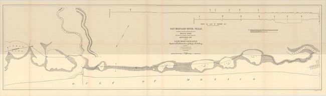
C. San Bernard River, Texas, Showing Possible Connection with Brazos River and Part of Possible Connection with Matagorda Bay for a Light Draft Navigation, by U.S. Corps of Engineers, dated 1899 (54.4 x 14.6"). Shows a potential route from the San Bernard River to the Brazos River by means of a canal and 5 connecting lakes.
D. Sketch Showing the Progress of the Survey in Sections 8 & 9 from 1846 to 1882, by U.S. Coast & Geodetic Survey, dated 1886 (34.7 x 20.3"). Shows the extent of survey work from Sabine Lake east to the Mississippi Delta. Includes a small inset of "Vicinity of the Rio Grande" at bottom left.
E. Reconnaissance for Triangulation Along the Rio Grande from El Paso to the Gulf of Mexico, by U.S. Coast & Geodetic Survey, dated 1895 (21.4 x 15.1"). Presents the extent of survey work along the Rio Grande in Texas.
F. Gulf Coast Ship Shoal to the Rio Grande, by U.S. Coast & Geodetic Survey, dated 1887 (23.1 x 18.1"). This index map extends from Brownsville, Texas to Morgan City, Louisiana and depicts Laguna Madre, Matagorda Bay, Vermilion Bay and more. Locates the Trinity Shoal Light Ship off the Louisiana coast.
References:
Condition: A
The charts are all near fine with occasional faint toning along the fold lines.