Subject: Southern California
Period: 1865-70 (circa)
Publication:
Color:
This lot contains three interesting items that were found loose within a copy of the Report of the Commissioner of the General Land Office for the year 1866:
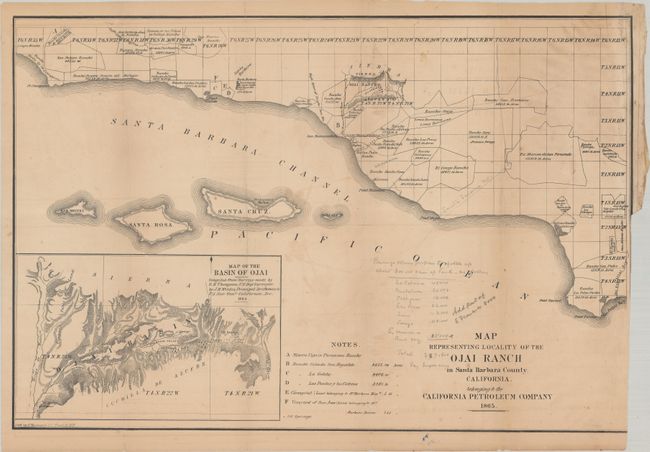
A. Map Representing Locality of the Ojai Ranch in Santa Barbara County, California. Belonging to the California Petroleum Company, by G. Hayward, dated 1865, black & white (23.0 x 15.4"). This map was originally issued in A Description of the Recently Discovered Petroleum Region in California by Benjamin Silliman. It covers the California coast from Point Concepcion to San Pedro Bay with the Channel Islands off the coast. The map locates the Spanish ranchos with their boundaries and acreage, and includes a detailed inset entitled "Map of the Basin of Ojai." This inset depicts some of the earliest oil springs found on a California map. Streeter notes that these two maps together represent "very early large scale maps of what has become one of the most prosperous regions of California." This working example features some interesting pencil notations below the map including "Banning's scheme proposes to gobble up 300,000 acres as follows." Below this sentence are a number of ranchos with acreages noted, no doubt used as part of a potential real estate transaction. Condition: Issued folding with a binding trim at lower right with border trimmed away. There is light toning, minor foxing, and a few short splits at the fold junctions. A number of pencil notations are mostly in blank areas of the map. (B)
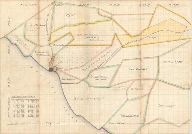
B. [Manuscript Map of Ventura County Spanish Land Grants], circa 1870, hand color (19.3 x 13.6"). An interesting manuscript map covering a similar region to the printed map above. Drawn on old lined paper, it shows the Spanish ranchos in the area that would become Ventura County. Includes a small block plan for San Buenaventura (Ventura) with an extension labeled "Tract No. 1" with some related field notes at bottom. Condition: Issued folding with light soiling and archival repairs to a few fold separations and an edge tear. (B)
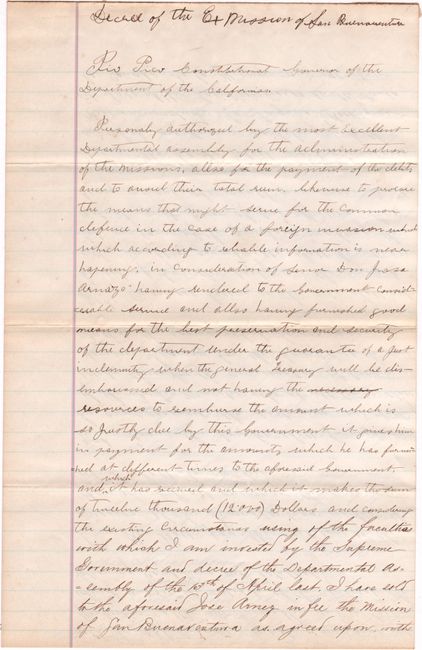
C. Decree of the Ex Mission of San Buenaventura, circa 1870, black & white (8.0 x 12.5"). This 2-page manuscript letter is an old copy of a decree issued in 1846 by Pio Pico, the last Governor of Mexican California. The decree passes ownership of the Rancho Ex-Mission San Buenaventura, a nearly 49,000 acre tract, to Jose de Arnaz. Condition: Just a hint of toning. (A)
References: Streeter #2903; Sabin #81051.
Condition:
See description above.