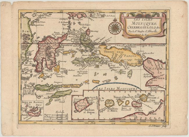
Subject: Eastern Indonesia
Period: 1699 (published)
Publication: Geographise en Historise Werelt Beschryving
Color: Hand Color
Size:
9.7 x 7.4 inches
24.6 x 18.8 cm
This lovely map of the East Indies covers the famous Spice Islands and includes insets of Banda, Bachian and the Moluccas. Terre des Papous is rendered as an island separate from New Guinea, following an error that began in the 1590s. The map is beautifully engraved and decorated with a strapwork title cartouche and a compass rose. Engraved by Antoine d'Winter.
Sanson's small maps from his L'Asie en Plusieurs Cartes..., first published in 1652 and engraved by A. Peyrounin, were copied several times by various map publishers. Johann David Zunners made copies of Sanson's maps for his German translation of Die Gantze Erd-Kugel in 1679. Johannes Ribbius and Simon de Vries published copies in 1682 and 1683, with new maps engraved by Antoine d'Winter. The plates were later sold to Francois Halma, who used them in 1699 and then again in 1705 with the titles re-engraved in Dutch. The titles on the d'Winter plates were re-engraved back into French, and then used by Nicholas Chemereau in 1715 and by Henri du Sauzet in 1738.
References: Pastoureau, SANSON III F bis.
Condition: A
A crisp impression with minor toning and a small worm hole in the right blank margin.