Subject: Southwestern United States & Mexico, California
Period: 1683 (published)
Publication: Geographise en Historise Werelt Beschryving
Color: Hand Color
Size:
9.4 x 7.9 inches
23.9 x 20.1 cm
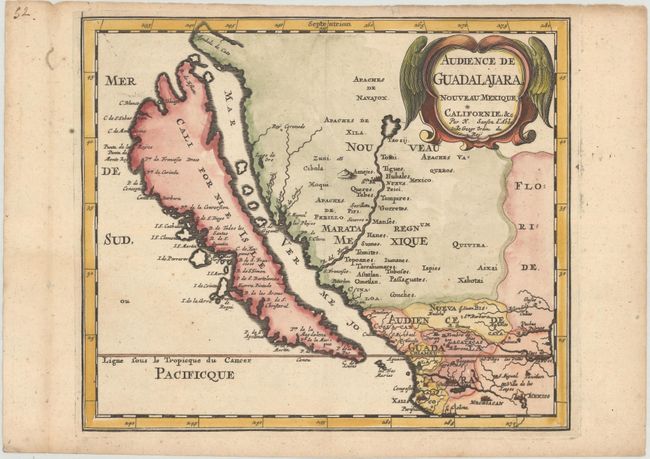
This map was first published in 1656 and introduced the so-called second Sanson model of California as an island. This depiction shows a small peninsula (Agubela de Cato) above the island, two bays along the island's northern coast and two new place names, Tolaago and R. de Estiete. Sanson actually based this on information from the less well known map by Luke Foxe, but it was this map that influenced many other cartographers throughout the rest of the century. On the mainland there are new Indian tribes identified in the region of the R. del Norte, which flows southwest from a large inland lake. This is the first state of the Ribbius edition, prior to the addition of a grid of longitude and latitude.
Sanson's small maps from his L'Amerique en Plusieurs Cartes..., first published in 1656 and engraved by A. Peyrounin, were copied several times by various map publishers. Johann David Zunners made copies of Sanson's maps for his German translation of Die Gantze Erd-Kugel in 1679. Johannes Ribbius and Simon de Vries published copies in 1682 and 1683, with new maps engraved by Antoine d'Winter. The plates were later sold to Francois Halma, who used them in 1699 and then again in 1705 with the titles re-engraved in Dutch. The titles on the d'Winter plates were re-engraved back into French, and then used by Nicholas Chemereau in 1715 and by Henri du Sauzet in 1738.
References: Burden #576; McLaughlin #16; Pastoureau, SANSON II F bis; cf. Tooley (Amer) p. 116, #15.
Condition: A
A dark impression with marginal soiling.