Subject: Central United States
Period: 1993 (published)
Publication:
Color: Hand Color
Size:
31.9 x 16.6 inches
81 x 42.2 cm
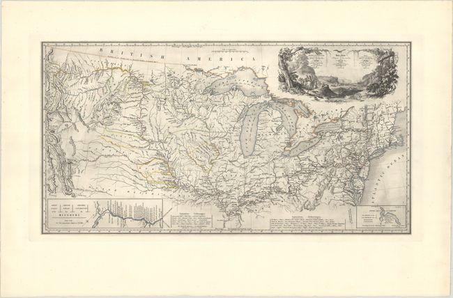
This is a restrike from the original plate tracing the journey of Prince Maximilian of Wied along the Missouri River, first published in 1839. The map spans from the Rocky Mountains through the Great Plains and Midwest to the Mid-Atlantic and New England. It charts the prince's entire course from his entourage's arrival in Boston in July 1832 to his April 1833 departure up the Missouri River to the Rockies on the steamship Yellow-Stone. His return route, which took him along Lake Erie and through Upstate New York, is shown as well. There is remarkably accurate detail of the Upper Mississippi and Missouri River watersheds, and plenty of towns and cities, Indian tribes, and forts are named along the way. An inset at bottom left depicts the "Great Falls of the Missouri," while another inset at bottom right zooms in on Lake Itasca. The map features an inaccurate rendering of the route of Zebulon Pike, indicating that the mapmaker perhaps confused Pike, Long, and Bell. The 1807 route of John Colter around Yellowstone is copied from Lewis and Clark. A beautifully engraved title cartouche adorns the top right corner, featuring natives, a bear and other wildlife, and a distant waterfall.
Prince Maximilian of Wied-Neuwied (1782-1867) was an explorer, ethnologist, and naturalist who had already explored Brazil by the time he embarked on his travels up the Missouri River in 1832. He was accompanied by the artist Karl Bodmer (1809-1893), whose aquatint engravings captured the culture of the Native Americans the party encountered along their journey. The aquatint engravings that resulted from that expedition are among the finest and most important representations of the Native Americans of the Midwest.
Although this map is often attributed to Bodmer (including in Wheat), modern research suggests that the map is by Lt. Col. William Thorn, drawing from Tanner's 1837 Map of the United States of America. In 1993, the original map plate was reprinted in a limited edition by Alecto Limited. This is number 138 of the restrikes.
References: Rumsey #3830; Wheat #445.
Condition: A+
Superb dark impression on a bright sheet with a couple of insignificant spots of foxing in the wide, blank margins.