Subject: York River, Virginia
Period: 1857 (dated)
Publication:
Color: Hand Color
Size:
22.9 x 16.6 inches
58.2 x 42.2 cm
The Office of Coast Survey is the oldest U.S. scientific organization, dating from 1807 when Congress directed that a "survey of the coast" be carried out. By 1836, it was called the U.S. Coast Survey and in 1878, the name was changed to the U.S. Coast and Geodetic Survey. Today the Office of Coast Survey is a division of the National Oceanic and Atmospheric Administration NOAA.
The survey teams, composed of civilians as well as Army and Naval officers, charted the nation's waterways and produced a wide array of reports, survey charts, hydrographic studies of tides and currents, astronomical studies and observations, and coastal pilots. These charts are an important record of the changing nature of the nation's coastlines. In additional to coastal charts, the U.S. Coast and Geodetic Survey produced land sketches, Civil War battle maps, and the early aeronautical charts.
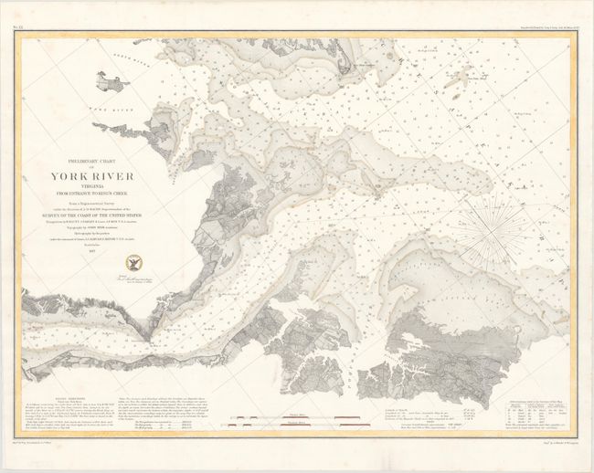
This detailed chart covers the entrance to the York River from Chesapeake Bay. It features great detail of the navigational channels and hazards and the topography of the coastlines. Bottom types and depth soundings fill the waters. Triangulation by E. Blunt, J. Farley, and Lieut. J.P. Roy. Topography by John Seib. Hydrography supervised by Lieuts. J.J. Almy and R.D. Minor.
References:
Condition: A
On a bright sheet, issued folding, now flattened and backed in archival tissue.