Subject: Ancient World
Period: 1511 (circa)
Publication: Claudii Ptholemaei Alexandrini Liber Geographiae cum Tabulis…
Color: Printed Color
Size:
21.9 x 11.3 inches
55.6 x 28.7 cm
Claudius Ptolemy was a mathematician, astronomer and geographer who worked in Alexandria, then a part of the Roman Empire, in the 2nd century AD. One of the most learned and influential men of his time, his theories dominated both astronomy and geography for nearly 1500 years. His writings were kept alive by Arabic scholars during the Middle Ages and reemerged in Europe during the Renaissance. The birth of printing led to wide dissemination of his great works on astronomy and geography. There were a number of editions of his Geographia beginning in 1477. These early editions contained maps based on his original writings, known as Ptolemaic maps. As geographic knowledge increased with the explorations of Columbus, Magellan, Cabot and others, maps of the New World were added, and maps of the Old World were revised. Ptolemy's Geographia continued to be revised and published by some of the most important cartographers including Martin Waldseemuller, Sebastian Munster, Giacomo Gastaldi, Jodocus Hondius, and Gerard Mercator (whose last edition was published in 1730).
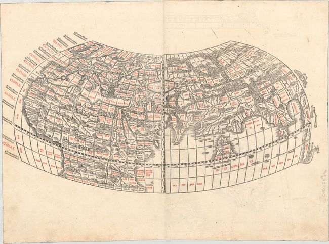
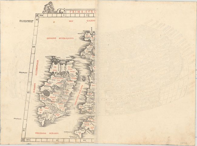
This rare and distinctive ancient world map, from the 1511 edition of Ptolemy's Geograhia, is an extremely early example of 16th century Venetian cartography and one of the earliest maps obtainable by today's collectors. This Latin edition of Ptolemy was the first published in Venice, by Jacobus Pentius de Leucho, and was the first atlas to use two-color woodblock printing. The maps were printed in black with place names and headings printed in red ink by means of type set into the woodblock and applied with a second strike of the plate. The text was based on a Latin translation by Jacobus Angelus, with revised maps by Bernardus Sylvanus. Little is known of Sylvanus, a native of Southern Italy, although he is believed to have been a monk. Realizing that Ptolemy's maps were outdated, Sylvanus set out to update them with modern information, often from contemporary manuscript sources. The resulting effect was an unusual hybrid of classical and modern information. Sylvanus also introduced a new "modern" world map, depicted for the first time in a distinctive cordiform (heart-shaped) projection, which was adopted by several later cartographers and used for a number of important 16th century maps.
This ancient world map was updated with contemporary sources. These updates include the British Isles, which are shown in a non-Ptolemaic style, and the interior of Africa south of the equator. The Indian peninsula has begun to take shape, and the land link between southern Africa and Asia has been eliminated. The land masses are vigorously engraved with mountain ranges, rivers and place names, and the map is surrounded by the climates to the left and three signs of the zodiac to the right. The unique projection of the map seems to imply that the world is a sphere. Printed on two sheets, joined. On verso is a partial map of the British Isles.
References: Mickwitz & Miekkavaara #204-1; Shirley #31.
Condition: B+
An excellent impression on watermarked paper with light soiling. Trimmed by the bookbinder at left, with minor loss of image.