Subject: North America, Texas
Period: 1813-46 (circa)
Publication:
Color: Hand Color
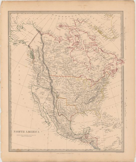
A. North America, by SDUK Society for the Diffusion of Useful Knowledge, circa 1843 (12.6 x 15.1"). Detailed and finely engraved map that portrays an Independent Texas, with Mexico controlling Nueva California. The boundary between Canada and the United States is left unengraved, leaving the ownership of Oregon Territory (here labeled Columbia) unknown, which is unusual for a British map. Filled with well-developed topography, the map names numerous forts, trading posts, Indian tribes and locates L. Youla roughly near the Great Salt Lake with the American Fur Depot on its eastern shore. The R. Buenaventura extends to the Pacific from two branches, one originating from a large swamp in the Great Basin. The course of the Snake River is fairly accurate, but the Colorado River originates too far north and rushes to the Sea of Cortez in a straight line. Locates the 3 buttes in present-day Idaho -- important landmarks on the Oregon Trail. Lake Michigan retains its erroneous elongated shape. Distance scales outside of border give English Miles and Spanish Leagues. Engraved by J. & C. Walker and published by Charles Knight. Condition: Original outline color with light toning and faint scattered foxing. (B+)
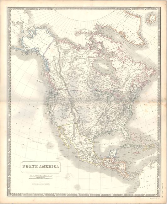
B. North America, by W. and A. K. Johnston, circa 1846 (19.4 x 23.9"). This remarkably detailed map is filled with interesting geography. The independent Republic of Texas is shown with its border extending well north. Upper or New California occupies the entire southwest and present day California. In the northwest, the Canadian border dips down to the Columbia River, however, a note in the Pacific references the Oregon boundary settlement and the correct border has been overlaid on top of the map. Filled with place names, early railroads, forts, Indian villages, and much more. Surrounded by piano-key borders and a simple title cartouche. Condition: Light scattered foxing along the fold at right and minor soiling in the blank margins. (B+)
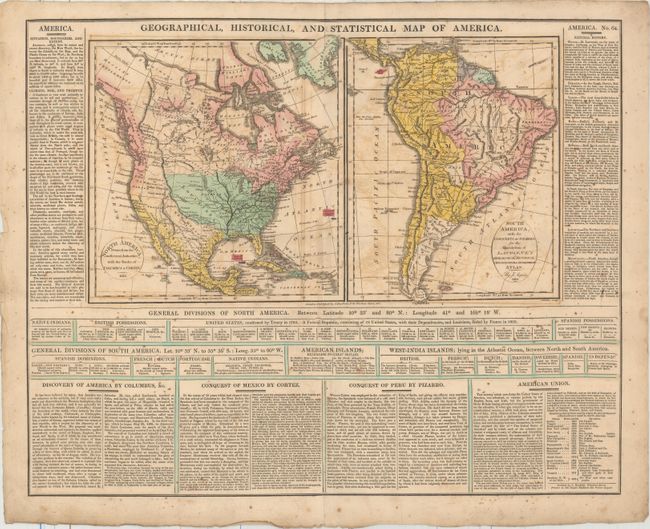
C. Geographical, Historical, and Statistical Map of America, by John Barfield, dated 1813 (15.8 x 9.0"). Two maps on a large sheet (19.8 x 15.8") surrounded by English text. The map of North America is about 8 x 9" and South America is 7 x 9". The United States extends to the Continental Divide and the western coast of North America is noted by "Vancouver's Surveys." The surrounding text gives much information on the climate, history, and discovery of the Americas. This is the English edition of Lavoisne's map. Condition: Light scattered foxing and moderate offsetting. (B)
References:
Condition:
See description above.