Catalog Archive
Auction 156, Lot 477

"Carte Generale des Voies de Communication de la France et des Etats Limitrophes Indiquant les Routes, les Chemins de Fer, les Rivieres Navigables et les Canaux...", Vuillemin, Alexander A.
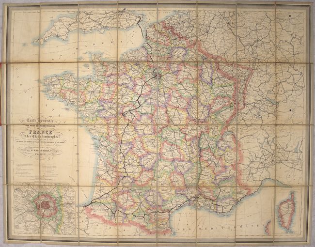
Subject: France

Period: 1870 (circa)

Publication:

Color: Hand Color

Size:
33 x 25.8 inches
83.8 x 65.5 cm
Download High Resolution Image
(or just click on image to launch the Zoom viewer)

This folding map of France is dense with detail. It is divided into departments and locates towns and cities, railways both completed and under construction, roads, canals, mountains, rivers, and more. Portions of bordering nations are depicted as well. Steamboat routes are delineated in the English Channel (La Manche) and the Mediterranean. An inset at bottom left details Paris and its surroundings, and another inset at bottom right focuses on the island of Corsica. Engraved by Ch. Smith, with lettering by Isidore Dalmont. The map is dissected, backed in linen, and folds into red cloth-covered boards.

References:

Condition: B

There is some minor offsetting, light soiling, and light toning primarily along the folds. There are manuscript notations in blank ink from a previous owner. There is wear and a light stain on the covers.

Estimate: $100 - $130

Sold for: $75

Closed on 2/17/2016

Archived