Subject: Northern Asia
Period: 1705 (circa)
Publication: Noord en Oost Tartarye
Color: Hand Color
Size:
14.3 x 11.1 inches
36.3 x 28.2 cm
Nicolaas Witsen (1641-1717) was a Dutchman who was a cartographer, authority on shipbuilding, administrator of the VOC, and served as mayor of Amsterdam multiple times. Witsen traveled to Moscow in 1664-65, keeping a diary and collecting artifacts. He became fascinated about Russia and obtained all information available at the time on the subject, including maps, travelogues, manuscripts and objects. In 1692, Witsen published the most comprehensive and authoritative work on Russia and northern Asia, Noord en Oost Tartarye. A second expanded edition was published in 1705 with additional maps, and again reprinted in 1785. All editions are very rare.
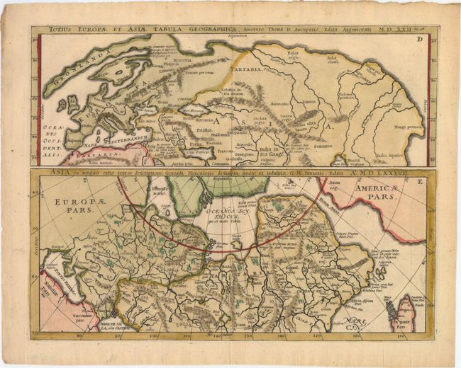
This sheet includes two maps. The upper map extends from Europe to Asia, and as far south as the Persian Gulf and the tip of the Bay of Bengal. The map is based on the work of Thoma D. Aucupario circa 1522, and is very rudimentary. Greenland is depicted as an elongated peninsula attached to Russia and Scandinavia is quite misshapen. The lower map depicts northern Asia based on Gerard Mercator's map of Asia in 1587. Although the cartography is focused on the rivers and mountain ranges in the region, the interesting features of the map are in the Arctic, with a large Nova Zemla and another landmass to the north of Russia. Americae Pars appears to the east of Russia, separated by the Fretum Anian, with a large rock labeled Polus magnetis just to the north. A fascinating and rare map.
References:
Condition: A
A nice impression with attractive color on paper with a "Pro Patria" watermark.