Subject: Chesapeake Bay, Virginia
Period: 1751 (circa)
Publication: The English Pilot. The Fourth Book…
Color: Hand Color
Size:
23.9 x 18.1 inches
60.7 x 46 cm
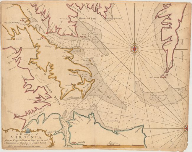
This plan covers the southern Chesapeake Bay, James River and York River, and is regarded as the first published regional map of Virginia. As Virginia's population expanded dramatically during the early 18th century, settlers began moving further up the rivers in the Tidewater region in order to find good land. This growth created a need for more detailed and larger-scale maps of the region. This map was created by Mark Tiddeman, who conducted hydrographic surveys of the area as master of the Royal Navy ship Tartar from 1725-28. Tiddeman's logbook survives in the British National Archives and includes notes about the Tartar stopping and inspecting ships encountered along the coast, suggesting that his mission in the area may also have included compliance checks to enforce British customs laws. Tiddeman's chart is filled with extensive detail of soundings, creeks, inlets, and shoals, including Middle Ground shoal, which is noted as "Almost Dry." The cities of Williamsburg, Gloucester, York and Norfolk are pictorially depicted. Just below the eastern panhandle is the notation "Here the Tartar lost her Anchor Octobr. 17th 1726," referring to Tiddeman's vessel.
References: Sellers & Van Ee #1492; Stephenson & McKee #II-32; Wooldridge #94; Shirley (BL Atlases) M.M&P-5b #16.
Condition: B
Trimmed to the neatline at lower right with two tiny chips that just enter the neatline. There are damp stains along edges of image, light soiling, and a short centerfold separation at bottom closed on verso with paper tape.